AP Human Geography
111 study materials · 72 sections
AP Human Geography students working the current College Board Course and Exam Description, including first-time students with no prior background, plus teachers reviewing the page for CED alignment.; Teach every official CED unit and every numbered topic at topic granularity.; Develop every AP skill / science-practice code explicitly and by name.; Replace description with teaching: worked contextual examples, named misconceptions, and in-flow retrieval checks.; Build an exam-practice unit covering every task type on the current exam.
Course Sections
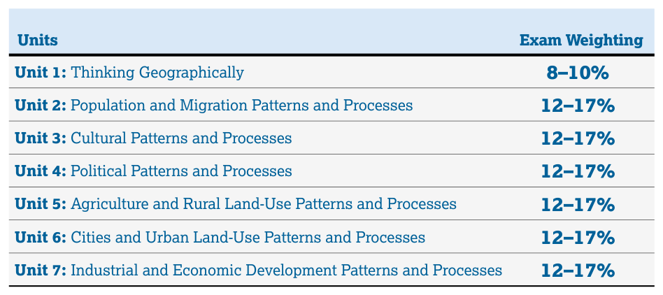
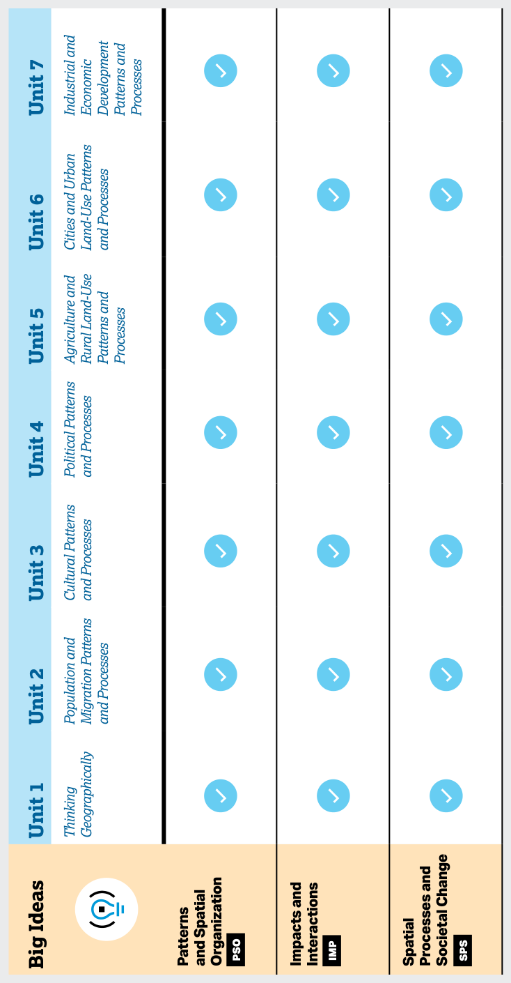
Course Framework, Skills and Reasoning Processes
Key concepts: AP Human Geography course framework · Industrial and Economic Development Patterns and Processes · Spatial relationships · Spatial processes and societal change · Scale analysis · Source analysis · Impacts and interactions · Progress Checks · AP Question Bank · Instructional model
AP Human Geography studies how people organize space, change places, and produce geographic patterns through spatial relationships, spatial processes and societal change, scale analysis, source analysis, and the effects of human-environment impacts and interactions.
1.1 Introduction to Maps
Key concepts: maps · spatial patterns · cow’s milk production · Africa · clustered or concentrated distributions · language as a cultural trait · comparing maps
A map turns “where?” into evidence. A list may tell you how much cow’s milk Africa produces, but only a map can reveal whether production is spread evenly, concentrated in a few regions, or clustered in neighboring countries.
1.2 Geographic Data
Key concepts: Geographic data · Maps · Quantitative data · Geospatial data · Map-based identification · Spatial analysis · Language patterns · Cultural traits · Food preferences as cultural traits · Ethnic neighborhood clustering
Geographic data are information organized around locations, allowing geographers to ask not only what is happening, but also where, how much, and in what spatial pattern.
1.3 The Power of Geographic Data
Key concepts: Geographic data · Geospatial data · Quantitative data · Spatial relationships · Scale of analysis · Patterns and processes · Relationships among places · Geographic perspectives · Time-space compression · Distance decay
A map becomes geographically powerful when it does more than show where something is: it helps explain why that pattern occurs, how places are connected, and what changes across scale.
1.4 Spatial Concepts
Key concepts: Spatial patterns · Spatial distribution · Spatial relationships · Diffusion · Domestication · Agglomeration · Clustering · Relative location · Geographic scale · Source analysis
A spatial pattern is never random decoration on a map: it records where phenomena are located, how they are arranged, and what relationships connect them.
1.5 Human–Environmental Interaction
Key concepts: Human–environment interaction · Environmental determinism · Possibilism · Geographic concepts · Natural environment · Environmental sustainability · Relationships among geographic factors · Environmental injustice · Housing discrimination · Pull factors
A flooded neighborhood, a heat-exposed apartment, or a farm beside a shrinking reservoir reveals the same geographic question: how do natural environments influence human societies, and how do human decisions reshape those environments?
1.6 Scales of Analysis
Key concepts: scales of analysis · spatial patterns · relationships among places · supranational organizations · shared decision-making · state sovereignty · regional scale · national scale · agglomerations · specific infrastructure and locations
A map can show an entire country while hiding the places, infrastructures, and relationships that make the country function. Scale of analysis is the geographic level—global, regional, national, or local—at which a pattern or process is examined.
1.7 Regional Analysis
Key concepts: Regional analysis · Types of boundaries · Site characteristics · Spatial distribution of political power · Ethnic residential patterns · Regional scale and map limitations · Territoriality and devolution · Climate-based crop specialization and regional interdependence · Spatial concentration of economic activities · Linear and regional concentration
A region is an area grouped together because its places share a characteristic, function, or perceived identity. Regional analysis turns a complicated map into a meaningful pattern: instead of asking only where is something?, geographers ask which places belong together, why, and at what scale does that grouping…
2.1 Population Distribution
Key concepts: Population distribution · Population density · Societal effects of population distribution and density · Environmental effects of population distribution and density · Global cultural patterns · Global political patterns · Global economic patterns · AP Human Geography learning objectives · Chief Reader Report on Student Responses · AP Human Geography Set 1 (2025)
Population distribution is uneven because people choose, or are compelled, to live where environmental conditions, economic opportunities, transportation, political stability, and historical settlement patterns make life more feasible.
2.2 Consequences of Population Distribution
Key concepts: Population distribution and its consequences · Mortality, fertility, and migration · Environmental, economic, cultural, and political influences on population change · Malthusian theory and critiques · Agricultural practices and their environmental and social impacts · Challenges of feeding a growing population · Green Revolution technologies and agricultural surplus · Core-periphery patterns in bilingual populations · Medical care and death rates · Pronatalist and antinatalist population policies
Population distribution changes society because the number of people a place can support—and the way those people are arranged—affects resources, health, economies, culture, and political power.
2.3 Population Composition
Key concepts: Population composition · Population pyramids · Using population pyramids to predict future population needs · Data analysis of population information
A country’s population is not just a total count: its population composition—the characteristics of the people who live there—reveals what services it needs now and what pressures it may face later.
2.4 Population Dynamics
A population can grow even when families are having fewer children—and shrink even when births still outnumber deaths—because population dynamics tracks the combined effects of natural change and migration.
2.5 The Demographic Transition Model
Key concepts: Demographic Transition Model (DTM) · Population change over time · Epidemiological transition · Fertility rates · Mortality rates · Migration rates · Crude birth rate · Crude death rate · Rate of natural increase · Population pyramids
A country can move from rapid population growth to population decline even when people live much longer. The Demographic Transition Model (DTM) explains this historical change by tracking how fertility rates and mortality rates change as environmental, economic, cultural, and political conditions change.
2.6 Malthusian Theory
Key concepts: Malthusian Theory · Population growth · Food production · Agricultural technological advancements · Agricultural revolutions · Expensive farm inputs · Agricultural production costs · Farm profitability · Rural-to-urban migration · Wealth gap between farms
A population can grow rapidly even while the food system supporting it changes slowly. Malthusian theory is the argument that population growth can eventually outpace food production, creating pressure on resources and lowering living standards unless population growth is checked.
2.7 Population Policies
Key concepts: Pronatalist population policies · Antinatalist population policies · Government incentives and social programs · Population growth rates and fertility · Drivers of population decline · Women’s education, employment, and fertility · Immigration and emigration · Population pyramids and demographic planning · Limits of population pyramids for measuring immigration · Urbanization and population change
A government can change population patterns not only by counting births and deaths, but by changing the conditions under which people decide whether and when to have children.
2.8 Women and Demographic Change
Key concepts: Women’s social and economic roles · Education and employment of women · Fertility and birth rates · Demographic Transition Model stages 3 and 4 · Population growth and decline · Rate of Natural Increase (RNI) · Doubling time · Age of marriage · Infant mortality and fertility · Economic effects of demographic change
When women gain greater access to education and paid employment, fertility usually declines because marriage and childbearing are often delayed, the opportunity cost of raising children increases, and families gain more control over reproductive decisions.
2.9 Aging Populations
Key concepts: Aging populations
An aging population is one in which the proportion of older people increases relative to the total population. The change can result from longer lives, fewer births, or the movement of younger adults away from a place—and it can reshape labor markets, public budgets, family life, and political priorities.
2.10 Causes of Migration
Key concepts: Seasonal migration · Transhumance · Pastoral nomadism · Resource availability · Grazing plants · Water access · Arid environments · Sahel region · Seasonal environmental conditions · Migration routes
In the Sahel, a herd cannot graze in one place indefinitely because rainfall, grazing plants, and water access shift across space and through the seasons.
2.11 Forced and Voluntary Migration
Key concepts: Forced migration · Voluntary migration · Refugees · Internally displaced persons (IDPs) · Asylum seekers · Slavery · Chain migration · Family migration · Guest workers · Brain drain
Migration is not one uniform process: some people move because they choose or are able to pursue a different opportunity, while others move because remaining where they are has become impossible or unsafe.
2.12 Effects of Migration
Key concepts: In-migration · Out-migration · Labor force · Entrepreneurship · Economic development · Employment and wages · Tax revenues · City infrastructure · Quality of life · Social development
A city can gain workers, businesses, and tax revenue when people move in—but it can also face housing and infrastructure pressure. When people move out, the same city may lose employees, customers, investment, and public revenue.
3.1 Introduction to Culture
Culture is the shared system of practices, technologies, attitudes, and behaviors that a society passes from one generation to another. It helps explain why people in different places eat different foods, organize family life differently, attach different meanings to clothing, or respond differently to the same…
3.2 Cultural Landscapes
Key concepts: Cultural landscapes · Physical geography · Human cultural practices · Placemaking · Ethnic traditions · Sequent occupance · Visual landscape elements · Intangible cultural elements · Functional land-use patterns · Pastoral nomadism in the Sahel
A landscape is never only “natural.” A street sign in two languages, a mosque beside a market, seasonal grazing routes, traditional clothing, and the crops planted in nearby fields can all reveal who lives in a place, what they value, and how earlier groups occupied it.
3.3 Cultural Patterns
Key concepts: Cultural convergence · Cultural divergence · Migration and cultural diffusion · Global agricultural patterns · Cultural, economic, and environmental influences on agriculture · Communication technology and cultural change · Indigenous language loss and preservation · Language replacement by dominant languages such as English · Religion expressed through regional architecture · Visual-source analysis of cultural patterns
Cultural patterns are never random: they reveal how people, places, environments, economies, and technologies shape one another. A language map, a religious building, or an agricultural map can therefore be read as evidence of cultural processes—not merely as a collection of locations.
3.4 Types of Diffusion
Key concepts: Types of diffusion · Relocation diffusion · Hierarchical diffusion · Contagious diffusion · Stimulus diffusion · Blending of languages
A cultural idea can cross space in several different ways: people may carry it with them, influential places may pass it onward, neighbors may imitate one another, or another culture may borrow and modify it.
3.5 Historical Causes of Diffusion
Key concepts: Spatial diffusion · Hearths of domestication · Columbian Exchange · Crop diffusion · Colonialism · Indigenous languages · Immigration · Types of diffusion · Historical causes of diffusion · Spatial relationships
A potato domesticated in the Andes became a staple in Ireland, while maize from the Americas transformed diets in Africa and Europe. These changes were not random: historical spatial diffusion is the spread of a cultural trait, crop, language, or practice through time because of migration, trade, conquest,…
3.6 Contemporary Causes of Diffusion
Key concepts: Contemporary causes of diffusion · Cultural landscapes · Asian ethnic-group neighborhoods · Toponyms and religious diffusion · Agricultural practices and environmental effects · Chemical inputs and pollution · Mechanized farming · Irrigation and water competition · Conflicts between farmers and nomadic herders · Spatial relationships and source analysis
Contemporary causes of diffusion are modern forces that move cultural traits, practices, ideas, and technologies across space. Communication technologies, migration, transportation, globalization, and economic connections can make cultural contact faster and more extensive—but diffusion does not produce identical…
3.7 Diffusion of Religion and Language
Key concepts: Culture traits and the cultural landscape · Placemaking and sense of place · Centripetal and centrifugal cultural forces · Relocation diffusion · Hierarchical diffusion · Contagious diffusion · Stimulus diffusion · Language creolization · Diffusion of religion and religious toponyms · Cultural diffusion and musical syncretism
Language and religion do more than communicate ideas or express belief: they leave visible patterns across Earth’s surface. A place-name, mosque, church, bilingual road sign, festival, restaurant, or musical tradition can reveal how cultural traits moved, mixed, and became attached to place.
3.8 Effects of Diffusion
Key concepts: Diffusion · Effects of diffusion · Agriculture · Learning objectives · SPS-3.B · Enduring Understanding
Diffusion changes a cultural landscape when an idea, practice, technology, language, religion, or material object spreads from one place to another and is adopted, adapted, blended, or resisted.
4.1 Introduction to Political Geography
Key concepts: Political organization of space · Historical and current political processes and events · State sovereignty · Supranational organizations · Challenges to state sovereignty · EU and ASEAN · Communication technologies and sovereignty · Resource disputes on land and at sea · Gerrymandering
Political geography asks a deceptively powerful question: who controls which space, and how did that arrangement come to exist? The political organization of space results from historical and current processes, events, and ideas, so a political map is not simply a picture of borders—it is a record of conflict,…
4.2 Political Processes
A boundary may look like a line on a map, but political processes determine who draws it, who votes within it, and whose interests receive attention afterward.
4.3 Political Power and Territoriality
Key concepts: State · Nation · Nation-state · Stateless nation · Sovereignty and independent government · Nations aspiring to become states · Ethnic neighborhoods and spatial patterns · Assimilation and preservation of ethnic traditions · Redistricting and gerrymandering · Federal systems and the spatial distribution of political power
A state is a sovereign political entity with its own independent government. Because it controls territory, makes and enforces laws, and conducts relations with other states, the state is a primary building block of the world political map.
4.4 Defining Political Boundaries
Key concepts: Territoriality · Political geography · Political boundaries · Administrative control · Sovereignty · Internal boundaries · Natural-resource management · Ecosystem protection · International recognition · Foreign policy
Political boundaries are lines or zones that delimit where a government’s administrative authority applies. They turn territorial control into a visible political arrangement: a state, province, district, or other governing unit can claim jurisdiction over a defined area.
4.5 The Function of Political Boundaries
Key concepts: Political boundaries · Cultural, national, and economic divisions · Demilitarized zones · Berlin Conference · Land and maritime boundaries · International agreements · National and regional identity · International and internal interactions · Territorial seas · Exclusive economic zones
Political boundaries organize who governs a place, who may cross it, which resources a state may use, and how people imagine collective identity. A line on a map can therefore act simultaneously as a legal limit, a cultural symbol, an economic filter, and a source of conflict.
4.6 Internal Boundaries
Key concepts: Internal boundaries · Sovereignty · Government control · Subnational regions · Limits between subnational regions · Different types of subnational regions
Internal boundaries divide territory within a sovereign state, determining which subnational government controls a particular place. A single landscape may therefore be governed simultaneously by a national government, a province, a voting district, a school district, and a water district—each with its own boundary…
4.7 Forms of Governance
Key concepts: Sovereignty · State self-rule · Noninterference by outside states and entities · International recognition of states · Requirements for defining sovereignty
Sovereignty is more than a government’s ability to make rules: it is a state’s authority to govern its territory and population without outside interference and with recognition from the international community.
4.8 Defining Devolutionary Factors
Key concepts: Devolution · Devolutionary factors · State sovereignty · Challenges to sovereignty · Supranationalism · Unitary systems · Centralization · Urban and rural populations · Rural natural increase (RNI) · Political, economic, cultural, and technological change
A state can look unified on a political map while containing powerful forces pulling it apart. Devolution is the transfer of power from a central government to regional or local governments; in more extreme cases, devolution may produce autonomous regions, the fragmentation of a state, or complete state disintegration.
4.9 Challenges to Sovereignty
Key concepts: state sovereignty · territoriality · devolution · supranationalism · democratization · communication technologies · Scottish independence · Brexit and sovereignty · unitary and federal states · electoral district redistricting
State sovereignty is the authority of an independent government to control its territory, make and enforce its laws, and conduct its affairs without being controlled by an external power.
4.10 Consequences of Centrifugal and Centripetal Forces
Key concepts: Centrifugal forces · Centripetal forces · State sovereignty · State failure and state stability · Uneven economic development · Stateless nations · Ethnic nationalism and separatist movements · Devolution and autonomous regions · National identity and cultural unity · Language, ethnicity, and religion as political forces
A state can be pulled together by shared identity and infrastructure—or pulled apart by inequality, separatism, and distrust. Centrifugal forces are pressures that divide a state, while centripetal forces are pressures that unify it.
5.1 Introduction to Agriculture
Agriculture is the deliberate cultivation of plants and the raising of animals to produce food, fiber, fuel, and other goods. It is both an environmental activity and a human system: climate and soil set possibilities, while technology, markets, culture, government policy, and transportation shape what people…
5.2 Settlement Patterns and Survey Methods
Key concepts: Rural settlement patterns · Clustered settlements · Dispersed settlements · Linear settlements · Metes-and-bounds surveying · Township-and-range surveying · Long-lot surveying · Rural land-use patterns · Agricultural practices and resource availability · Visual source analysis
A rural landscape is not randomly assembled: the way homes, fields, roads, and water are arranged reveals how people use resources, move across space, and organize land ownership.
5.3 Agricultural Origins and Diffusions
Key concepts: Agricultural origins and diffusions · Agriculture and rural land-use patterns and processes · Interdependence among agricultural production regions · Comparative advantage · Trade relationships · Global food distribution networks · Types of diffusion · Source analysis
A crop’s birthplace and its modern center of production are often thousands of kilometers apart. Maize originated in Mesoamerica, yet it is now grown extensively across the United States, China, Brazil, and many other regions because domesticated species spread through cultural diffusion—the movement of ideas,…
5.4 The Second Agricultural Revolution
Key concepts: Second Agricultural Revolution · Agricultural technological advancements · Impacts of technological change on agricultural practices · Carrying capacity of land · Green Revolution · High-yield seeds · Agricultural chemicals · Mechanized farming · Food supply in the developing world · Environmental consequences of the Green Revolution
A farm’s carrying capacity is not fixed: when people improve tools, seeds, transportation, or land management, the same area can support a larger population. The Second Agricultural Revolution was the major period of agricultural technological advancement that increased productivity and transformed farming…
5.5 The Green Revolution
Key concepts: Green Revolution · Cultural diffusion · Agricultural technology · Comparative advantage · Carrying capacity · Food supply and food security · Malthusian theory · Agricultural specialization and monocropping
The Green Revolution transformed agriculture by combining new biological, chemical, water-management, and mechanical technologies to raise crop productivity. Its central geographic question is not simply “Did food production increase?” but rather: How did higher productivity change population support, trade, rural…
5.6 Agricultural Production Regions
Key concepts: Agricultural production regions · Availability of resources and cultural practices · Agricultural land-use patterns · Spatial relationships · Agricultural practices and landscape alteration · Slash-and-burn agriculture · Terrace farming and irrigation · Shifting cultivation and pastoral nomadism · Societal effects of agriculture · Spatial patterns of cow’s milk and pork production
Agricultural production regions are areas whose farming patterns reflect both economic purpose and cultural practice. A field system is never determined by climate or soil alone: farmers also respond to land costs, transportation, markets, dietary traditions, available labor, and the resources valued by a society.
5.7 Spatial Organization of Agriculture
Key concepts: Spatial organization of agriculture · Availability of resources and cultural practices · Agricultural practices and land-use patterns · Economies of scale in agriculture · Carrying capacity of land · Agricultural technology and productivity · Hearths of domestication and crop diffusion · Food supply chains linking production and consumption · Scale analysis and spatial relationships · Conflicts between nomadic herders, conservation organizations, and governments
A farm’s location and size are shaped not only by soil and climate, but also by technology, culture, markets, transportation, and political rules. The same agricultural landscape can therefore produce very different results depending on who controls resources, what consumers prefer, and how efficiently products…
5.8 Von Thünen Model
Key concepts: Von Thünen model · Scale analysis · Geographic scales · Rural land use · Transportation costs · Distance from the market · Concentric rings · Regions of specialty farming · Spatial relationships · Geographic models and theories
A farm’s location can matter almost as much as its soil: perishable or bulky products usually become less profitable as they travel farther from the market.
5.9 The Global System of Agriculture
Key concepts: Globalized agricultural system · Global food distribution networks · International trade and export commodities · Political relationships and infrastructure · Commodity chains · Commercial agriculture replacing family farms · Economies of scale · Carrying capacity · Spatial patterns of cow’s milk and pork production · Environmental and health impacts of intensive agriculture
A cup of coffee, a carton of milk, or a package of pork may cross several borders before reaching a consumer. Globalized agriculture is therefore an interconnected system in which production, processing, transportation, distribution, and consumption operate across multiple places and geographic scales.
5.10 Consequences of Agricultural Practices
Key concepts: Environmental effects of agricultural land use · Pollution from agricultural practices · Agricultural land-cover change · Desertification · Soil salinization · Conservation efforts · Slash-and-burn agriculture · Terrace farming · Irrigation and water-resource use · Sustainable agricultural practices
Agriculture does not simply use landscapes; it actively reshapes them. A field may produce food while also changing vegetation, soil chemistry, water supplies, and local ecosystems.
5.11 Challenges of Contemporary Agriculture
Key concepts: Contemporary agriculture · Agricultural production patterns · Agricultural consumption patterns · Environmental opportunities and challenges · Social opportunities and challenges · Economic opportunities and challenges · Cultural opportunities and challenges · Variation by location · Agricultural practices · IMP-5 enduring understanding
Agriculture is no longer shaped only by soil, climate, and traditional farming methods: biotechnology, global trade, aquaculture, and changing consumer preferences now connect farms, ecosystems, markets, and cultures across great distances.
6.1 The Origin and Influences of Urbanization
Key concepts: Urbanization · Population growth · Economic growth and industrialization · Infrastructure · Quality of life · Transportation and communication systems · Government development policies · Zoning and urban planning · Informal settlements · Urban governance
Urbanization is the increasing share of a population living in urban areas, together with the physical expansion and growing importance of cities. A city rarely grows for just one reason: people, jobs, infrastructure, government decisions, and connections to other places reinforce one another.
6.2 Cities Across the World
Key concepts: Cities across the world · Urbanization · Suburbanization · Edge cities · Exurbs · Urbanism · Greenbelts · Slow-growth cities · Sustainable urban options · Spatial relationships and geographic similarities and differences
A city is not simply a large settlement: it is a spatial concentration of people, activities, institutions, and connections whose form reflects both physical geography and human choices.
6.3 Cities and Globalization
Key concepts: Deindustrialization · International division of labor · Economic sector shift · Core countries · Higher-paying jobs · Outsourcing · Offshoring · Economic restructuring · Globalization · Metacities
Globalization links cities through production networks, but it does not distribute the same kinds of work or income evenly around the world. A shirt may be designed in a core-country city, manufactured in a newly industrialized country, shipped through several ports, and marketed through a global financial center.
6.4 The Size and Distribution of Cities
Key concepts: Urban hierarchy · Urban interdependence · Relative city size · City spacing · Primate city · Gravity model · Christaller’s Central Place Theory · Distribution, size, and interaction of cities · Central place theory and supermarket location · Urban concepts and geographic models
Cities are not scattered randomly across space: they form systems in which settlements differ in size and function, connect to one another, and occupy locations shaped by distance, resources, and access.
6.5 The Internal Structure of Cities
Key concepts: Internal structure of cities · Urban models and theories · Burgess concentric-zone model · Hoyt sector model · Harris and Ullman multiple-nuclei model · Physical geography and resources · Geographic variation in cities · Limitations of urban models · Quantitative urban data · Qualitative urban data
A city is not internally uniform: housing, industry, commerce, transportation, and government occupy different spaces because land values, accessibility, physical geography, historical development, and environmental resources vary across the urban area.
6.6 Density and Land Use
Key concepts: Population density measurement: arithmetic, physiological, and agricultural density · Impacts of different methods used to calculate population density · Carrying capacity and how it changes · Mechanization and irrigation increasing agricultural carrying capacity · High-yield seeds increasing agricultural productivity · Urban sprawl and land-use change · Habitat loss, fragmentation, and decreased biodiversity · Transportation networks, pollution, and urban heat islands · Land-use conflicts involving local food production, open space, and conservation · Irrigation expansion and conflicts with nomadic herders
A city can feel crowded while the surrounding region still contains enormous amounts of open land. Population density resolves this apparent contradiction by measuring how many people, farmers, or resources are associated with a given amount of space—but the result depends entirely on what land area and population…
6.7 Infrastructure
A city cannot function on buildings alone: it depends on infrastructure, the basic physical systems that move people, goods, energy, water, information, and waste through urban space.
6.8 Urban Sustainability
Key concepts: Urban sustainability · Quality of life and standards of living · High-quality urban infrastructure · Suburban sprawl · Habitat fragmentation and biodiversity loss · Urban heat islands · Transportation networks and traffic congestion · Land-use competition · Transportation-oriented development (TOD) · Multilevel urban governance
Urban sustainability asks whether a city can support a good quality of life over time without exhausting the environmental, social, and economic systems on which residents depend.
6.9 Urban Data
Key concepts: Urban housing affordability · High population density · Large or growing urban populations · Housing vacancies · Urban periphery · Distance from employment locations · Access to schools, transit, and services · Migrant housing difficulties
A city can grow faster than its housing supply, turning a population increase into higher rents, crowded neighborhoods, and long commutes. Urban data helps geographers connect these outcomes to measurable patterns such as population density, population growth, housing vacancies, and distance from employment locations.
7.1 The Industrial Revolution
Key concepts: Industrial Revolution · Industrialization · Population growth · Diffusion of technology and industry · Urbanization · Changing class structures · Colonialism · Imperialism · Industrial raw materials and markets · Source analysis of maps, images, and landscapes
The Industrial Revolution was a major transformation in which new technologies, available natural resources, and mechanized production changed how people worked, lived, moved, and organized society.
7.2 Economic Sectors and Patterns
Key concepts: Primary, secondary, tertiary, quaternary, and quinary economic sectors · Development patterns associated with different economic sectors · Core, semiperiphery, and periphery locations · Manufacturing location factors · Labor as a determinant of industrial location · Transportation networks and shipping containers · Break-of-bulk points · Least-cost theory · Markets and resources as influences on manufacturing location · Growth poles and infrastructure’s effects on society
A smartphone connects several economic sectors before it reaches your hand: minerals are extracted, components are manufactured, software is designed, advertising and retail services sell it, and researchers or executives coordinate innovation and strategy.
7.3 Factors Driving Industrialization
Key concepts: Urbanization · Migration to cities · Population growth in urban areas · Economic growth · Trade · Industrialization · Economic development · Transportation infrastructure expansion · Communication infrastructure expansion · Governance
Industrialization reshapes places by concentrating jobs, investment, infrastructure, and people in connected urban areas. A factory may begin as a single workplace, but its demand for labor, transport, housing, markets, and communication can transform an entire city.
7.4 Women and Economic Development
Key concepts: Women’s roles change as countries develop economically · Women’s participation in the workforce · Gender inequality in wages · Inequality in employment opportunities · Microloans · Small local businesses created by women · Improved standards of living · Gender parity · Government initiatives at different scales · Using quantitative and geospatial data to draw conclusions
Economic development can expand women’s economic choices without automatically producing gender equality. As economies change, women often move into paid employment and entrepreneurship, yet wage gaps and unequal access to desirable jobs may persist.
7.5 Theories of Development
A country can export valuable commodities and still remain vulnerable to poverty, debt, and unstable growth. Theories of development are explanations of why some places achieve higher levels of economic and social well-being than others—and why development does not follow one universal path.
7.6 Trade and the World Economy
Key concepts: Neoliberal policies · Free trade agreements · International trade organizations · Spatial connections and trade relationships · Economic interdependence · Deindustrialization · Complementarity · Comparative advantage · Trade agreements and national sovereignty · Free-trade, special economic, and export-processing zones
A soybean shipment from Paraguay can feed Argentina’s food system, support Paraguayan farmers, and connect both economies to global prices and trade rules. International trade is the exchange of goods and services across places; it grows when economies have different resources, skills, technologies, or production…
7.7 Changes as a Result of the World Economy
Key concepts: Outsourcing · Global economic interdependency · Free-trade zones · Special economic zones (SEZs) · Export-processing zones (EPZs) · Post-Fordist methods of production · Just-in-time delivery · Agglomeration and economies of scale · Deindustrialization · Supranational organizations and international trade
A smartphone may be designed in one country, assembled in another, and depend on minerals, chips, software, shipping, finance, and customers spread across dozens of countries.
7.8 Sustainable Development
Key concepts: Sustainable development · Resource depletion · Mass consumption · Effects of pollution · Impact of climate change · Poverty reduction programs and policies · Remittances, microloans, and social safety nets · Job creation and increased employment · Environmental protection measures · Human Development Index (HDI) comparison between Brazil and Afghanistan
Sustainable development means improving human well-being without using resources or damaging environments in ways that undermine future generations. It responds to four connected pressures: resource depletion, mass consumption, pollution, and the effects of climate change.
AP Practice 1
Key concepts: Centripetal forces · Centrifugal forces · Devolution · Multinational states · Autonomous regions · Unitary states · Uneven development · Urban infrastructure challenges · Population density · Absolute and relative distance
A state stays politically unified when forces pulling people together outweigh forces pulling them apart. Centripetal forces strengthen unity, while centrifugal forces weaken it; devolution occurs when power or authority shifts from a central government toward regional or local governments.
AP Practice 2
Key concepts: Cause-and-effect relationships among people, environments, and historical or contemporary actions · Comparing patterns and trends in maps, images, and landscapes · Infilling as a form of urban development · Population change through mortality, fertility, and migration · Environmental, economic, cultural, and political influences on population change · Connection between physical geography and agricultural practices · Enduring Understandings, Learning Objectives, and Essential Knowledge hierarchy · Evaluating the strengths, weaknesses, and limitations of geographic models and theories · Using written accounts and visual sources to analyze geographic patterns · Cyberattacks targeting networks operated by devolutionary groups and democracy movements
A city can grow without expanding outward: when vacant lots or underused parcels appear inside an established urban area, infilling occurs as landowners build small, often multifamily housing units within existing city blocks.
AP Practice 3
A free-response answer earns credit by making a defensible geographic claim and connecting it to evidence, not by repeating vocabulary. This original practice set uses a short stimulus and a multi-part response to rehearse the central AP Human Geography skills: Concepts and Processes, Spatial Relationships, Data…
AP Practice 4
A geographic pattern becomes meaningful only when you connect where something occurs with why it occurs there. In this original, unofficial stimulus-based free-response question, a map and data table require you to move from visual evidence to geographic explanation.
AP Practice 5
A strong free-response answer does more than name a geographic term: it connects a spatial pattern to a process, supports the connection with evidence, and explains why the outcome matters.
AP Practice 6
A strong free-response question (FRQ) answer does more than name a geographic term: it connects a concept to a place, explains a spatial relationship, interprets evidence, and follows the question’s command precisely.
Source Materials
- AP Human Geography Course and Exam Description
- AP Human Geography Course and Exam Description Clarifications and Corrections
- AP Human Geography Course Overview
- AP Human Geography Course at a Glance
- AP Human Geography Course at a Glance Poster
- AP Human Geography
- AP Human Geography
- AP Human Geography Sample Syllabus 1
- Figure — AP Human Geography Course and Exam Description (p. 1)
- Figure — AP Human Geography Course and Exam Description (p. 17)
- Figure — AP Human Geography Course and Exam Description (p. 23)
- Course Framework V.1 | 17 AP Human Geography Course and Exam Description
Study AP Human Geography on Lykke
This course page is free to open: signed out, you can read its first two sections, and signing in, on any plan, opens the rest. The free Lykke Chrome extension syncs your own Canvas courses, so ChatGPT, Claude and Muse can answer from your classes and deadlines. It only reads Canvas.
Add the free extensionSign in to open every section