From the free course AP Human Geography on Lykke
6.4 The Size and Distribution of Cities
Key concepts: Urban hierarchy · Urban interdependence · Relative city size · City spacing · Primate city · Gravity model · Christaller’s Central Place Theory · Distribution, size, and interaction of cities · Central place theory and supermarket location · Urban concepts and geographic models
Cities are not scattered randomly across space: they form systems in which settlements differ in size and function, connect to one another, and occupy locations shaped by distance, resources, and access.
6.4 The Size and Distribution of Cities
Cities are not scattered randomly across space: they form systems in which settlements differ in size and function, connect to one another, and occupy locations shaped by distance, resources, and access.
PSO-6.C — Learning Objective: Identify the different urban concepts such as hierarchy, interdependence, relative size, and spacing that are useful for explaining the distribution, size, and interaction of cities.
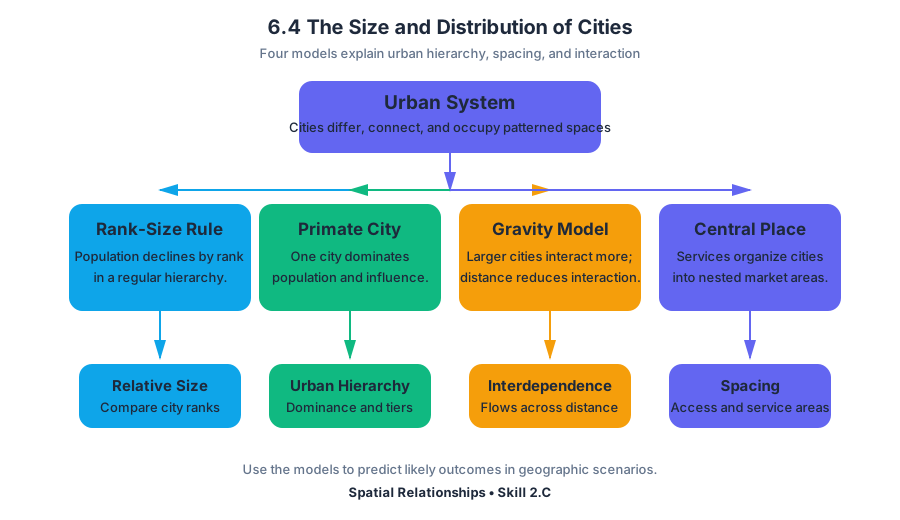
The required knowledge for this objective is PSO-6.C.1: principles useful for explaining the distribution and size of cities include the rank-size rule, the primate city, the gravity model, and Christaller’s central place theory. The associated suggested skill is Spatial Relationships, Skill 2.C: Explain a likely outcome in a geographic scenario using geographic concepts, processes, models, or theories.
Four ways to read an urban system
A city system can be analyzed through four related but distinct questions: How large and important is each city? How do cities interact? How far apart are they? What functions does each settlement perform?
| Concept | Main question | What it reveals |
|---|---|---|
| Urban hierarchy | How are cities ranked by size and function? | The organization of settlements from small centers to large metropolitan areas |
| Relative size | How large is one city compared with others? | Whether a system follows the rank-size rule or is dominated by a primate city |
| Urban interdependence | How do cities rely on and connect with one another? | Flows of people, goods, money, information, and services |
| City spacing | How are cities distributed across territory? | Whether settlements are clustered, dispersed, or arranged at regular intervals |
Hierarchy is an ordered system. A village may provide basic daily goods, a town may offer larger stores and secondary services, and a major city may contain specialized hospitals, universities, financial institutions, and government offices. The higher a settlement is in the hierarchy, the larger its market area and the less frequently people usually need its specialized services.
Relative size: rank-size and primate cities
The rank-size rule predicts that a city’s population is approximately equal to the largest city’s population divided by its rank. In simplified form, if the largest city has population $P_1$, the city ranked $r$ should have population:
$$P_r \approx \frac{P_1}{r}$$
Suppose a country’s largest city contains $4$ million people. Under the rank-size rule, the second-largest city would contain roughly $2$ million, the third-largest about $1.33$ million, and the fourth-largest about $1$ million. The rule is a general pattern, not a physical law; terrain, political history, colonial development, transportation, and economic change can produce major deviations.
A primate city is disproportionately larger and more influential than the other cities in its country. It often dominates political decision-making, higher education, finance, transportation, media, and cultural institutions. A primate-city pattern therefore differs from a rank-size distribution: the largest city is not merely first in rank but overwhelmingly dominant.
Misconception check: A primate city is not simply any country’s largest city. It is a city whose size and influence greatly exceed those of the next cities in the hierarchy.
Urban interdependence and interaction
Urban interdependence describes the connections among cities and the ways settlements rely on one another. A smaller city may send workers and students to a larger city, while the larger city depends on smaller places for labor, food, recreation, specialized manufacturing, or regional markets.
These relationships create spatial interaction: movement or communication between places. Interaction may include commuting, migration, tourism, freight shipments, investment, telephone calls, internet traffic, or patient visits to specialized medical facilities. Cities can compete for investment while remaining interdependent through shared transportation and economic networks.
The gravity model
The gravity model predicts that interaction between two places increases as their populations or economic masses increase and decreases as distance increases. A simple version is:
$$I_{ij} = G\frac{P_iP_j}{D_{ij}^{,b}}$$
Here, $I_{ij}$ represents interaction between cities $i$ and $j$, $P_i$ and $P_j$ represent their sizes, $D_{ij}$ is the distance between them, $G$ is a constant, and $b$ describes how strongly distance reduces interaction. The model does not claim that every pair of cities behaves identically; it provides a way to explain likely patterns.
For example, a large metropolitan area and a nearby medium-sized city may exchange more commuters and goods than two small, distant towns. However, a mountain range, international border, poor roads, language difference, or high transportation cost can reduce interaction below what population and distance alone would predict.
Spacing and Christaller’s central place theory
City spacing concerns the geographic distance between settlements and the pattern formed by their distribution. Cities may cluster near coasts, rivers, transport corridors, fertile land, or mineral resources; they may also be more evenly spaced when settlements serve surrounding rural populations in a regional service network.
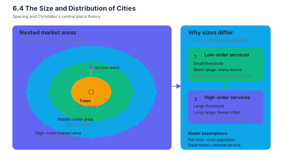
Christaller’s central place theory explains how settlements of different sizes can be distributed according to the services they provide. A central place is a settlement that supplies goods and services to the surrounding area, called its market area or hinterland.
The theory rests on an idealized landscape: a flat, evenly populated surface with similar transportation in every direction and consumers who travel to the nearest service. Under these assumptions, low-order services—such as convenience groceries—have small thresholds and short ranges, while high-order services—such as specialized surgery or major financial services—require larger populations and draw customers from farther away.
Christaller’s model is often represented with nested market areas. Smaller settlements are more numerous and more closely spaced because people need basic services frequently. Larger settlements are fewer and farther apart because their specialized services require larger customer bases.
Key insight: A settlement’s size is connected to its function. The city that offers rare, specialized services generally needs a larger market area than the town that sells everyday necessities.
Worked application: locating a new supermarket
A grocery company must choose between two sites: Site A is near a large city but faces several competing supermarkets; Site B lies between several smaller towns and has fewer competitors. Central place reasoning asks whether enough customers live within a practical travel range to support the store.
The likely evaluation proceeds as follows:
- Estimate the threshold, or minimum number of customers needed to keep the supermarket operating.
- Estimate the store’s range, or the maximum distance most customers will travel for groceries.
- Map nearby settlements and competing stores.
- Compare accessibility, roads, population density, and purchasing power.
- Choose the location with a sufficiently large underserved market area.
If Site B is easily reached by several towns and lies beyond the normal range of existing supermarkets, it may capture customers from a broad area. Site A may have a larger nearby population, but competition and congestion could shrink its effective market area. The best location is therefore not automatically the site with the largest population; it is the site where population, distance, accessibility, and competition combine to produce adequate demand.
Misconception check: Central place theory does not predict perfectly spaced hexagonal cities in the real world. Its geometric pattern is an analytical model, while physical geography, historical boundaries, unequal wealth, transportation, and technology make actual urban systems irregular.
Skill application: predicting an outcome
To apply Skill 2.C: Explain a likely outcome in a geographic scenario using geographic concepts, processes, models, or theories, name the model, identify the relevant evidence, and connect the evidence to the predicted outcome. For example: If a new high-speed rail link connects two large cities, interaction between them will likely increase because reduced travel time lowers the effective distance in the gravity model.
The same scenario may also change hierarchy and spacing. A smaller city located along the rail line could gain higher-order services and investment, strengthening its position in the urban hierarchy. The connection may increase interdependence even though the physical distance between cities has not changed.
Retrieval check
A country has one city of $8$ million people, a second city of $1.5$ million, and several much smaller cities. Which concept best describes this pattern, and what evidence supports the answer?
Answer: The pattern suggests a primate city because the largest city is disproportionately larger than the second-largest city. A rank-size pattern would predict the second city to be closer to $4$ million under the simplified rule $P_2 \approx P_1/2$; the observed $1.5$ million is far smaller.

Source Materials
- AP Human Geography Course and Exam Description
- AP Human Geography Course and Exam Description Clarifications and Corrections
- AP Human Geography Course Overview
- AP Human Geography Course at a Glance
- AP Human Geography Course at a Glance Poster
- AP Human Geography
- AP Human Geography
- AP Human Geography Sample Syllabus 1