From the free course AP Human Geography on Lykke
AP Practice 3
A free-response answer earns credit by making a defensible geographic claim and connecting it to evidence, not by repeating vocabulary. This original practice set uses a short stimulus and a multi-part response to rehearse the central AP Human Geography skills: Concepts and Processes, Spatial Relationships, Data…
AP Practice 3
A free-response answer earns credit by making a defensible geographic claim and connecting it to evidence, not by repeating vocabulary. This original practice set uses a short stimulus and a multi-part response to rehearse the central AP Human Geography skills: Concepts and Processes, Spatial Relationships, Data Analysis, Source Analysis, and Scale Analysis.
Task: Stimulus-based free-response question
Suggested timing: $25$ minutes. Spend about $4$ minutes reading the stimulus, $17$ minutes writing, and $4$ minutes checking that every part includes the requested evidence and explanation. The scenario combines the course big ideas of Patterns and Spatial Organization (PSO), Impacts and Interactions (IMP), and Spatial Process and Societal Change (SPS).
A rapidly growing coastal metropolitan region contains a dense central city, older industrial neighborhoods, suburban municipalities, and newly developing settlements along a highway corridor. Regional planners are considering a new commuter-rail line and are comparing population density, travel behavior, and access to employment.
| Zone | Population density in $2020$ (people per $km^2$) | Average commute time | Workers using public transportation |
|---|---|---|---|
| Central city | $8{,}400$ | $34$ minutes | $42%$ |
| Inner suburbs | $3{,}100$ | $39$ minutes | $18%$ |
| Outer suburbs | $1{,}250$ | $46$ minutes | $9%$ |
| Highway corridor | $2{,}000$ | $51$ minutes | $6%$ |
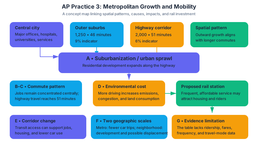
The central city contains the region’s largest concentration of offices, hospitals, universities, and government services. The highway corridor has experienced rapid residential construction, but employment has grown more slowly. Planners predict that a rail station in the corridor would encourage additional housing development and could reduce automobile dependence if frequent service and affordable fares were provided.
A. Identify the urban land-use process most directly associated with the outward expansion of residential development along the highway corridor.
B. Describe one spatial relationship shown by the data.
C. Explain one reason the highway corridor has a longer average commute than the central city.
D. Explain one likely environmental consequence of continued automobile-dependent growth in the highway corridor.
E. Explain one way the proposed commuter-rail line could produce a social or economic change in the corridor.
F. Explain how the likely effects of the rail line could differ between the metropolitan scale and the neighborhood scale.
G. Explain one limitation of using the table alone to evaluate whether the rail project would reduce automobile dependence.
Worked reasoning and scoring
A — 1 point: Identify the process. The correct identification is urban sprawl, meaning the low-density outward expansion of urban development into formerly rural or less-developed land. Simply writing “urbanization” is insufficient because urbanization is the growth of the urban population or urban areas generally; the stimulus specifically describes dispersed outward expansion.
B — 1 point: Describe a spatial relationship. A creditworthy response could state: “Population density decreases from the central city toward the outer suburbs, while the percentage of workers using public transportation also decreases.” This earns the point because it identifies a pattern using at least two categories of geographic information. A vague statement such as “the zones are different” does not describe a measurable relationship.
C — 1 point: Explain a cause using geographic concepts. The corridor has longer commutes because housing has expanded faster than employment, forcing many residents to travel toward the central city or other employment centers. Its peripheral location and limited public transportation increase dependence on automobiles and lengthen travel distances. The strongest answers connect location and accessibility to the outcome rather than merely stating that the corridor is “farther away.”
D — 1 point: Explain an environmental consequence. Continued automobile dependence would likely increase greenhouse-gas emissions and local air pollution because more residents would drive longer distances. Additional roads and low-density construction could also increase impervious surface, storm-water runoff, habitat fragmentation, and land consumption. One explained consequence is enough; listing several consequences without a causal connection does not earn additional credit.
E — 1 point: Explain a social or economic effect. A rail station could improve access to central-city jobs, universities, and services for residents who cannot drive, thereby increasing economic opportunity and labor-market connectivity. It could also attract transit-oriented development near the station. A complete explanation must show the mechanism: improved transportation access changes the spatial relationship between residents and opportunities.
F — 1 point: Analyze scale. At the metropolitan scale, rail could reduce regional automobile trips and connect the corridor to the central city. At the neighborhood scale, however, benefits may be uneven: households within walking distance of the station may gain access and property value, while distant neighborhoods may receive little benefit. New investment could also contribute to displacement if housing costs rise. This response demonstrates Scale Analysis, not merely a definition of scale.
G — 1 point: Identify a data limitation and explain its significance. The table does not show the number of automobile trips, the distance residents travel, the frequency of existing transit, household income, or changes over time. Therefore, it shows an association between location, density, commute time, and transit use but cannot by itself establish that a rail line would cause people to stop driving. A stronger evaluation would compare travel behavior before and after rail construction or examine similar corridors with and without rail service.
Skill map: what the examiner is rewarding
| Response part | Primary skill | Reasoning move |
|---|---|---|
| A, C, D, E | Skill 1. Concepts and Processes | Apply urbanization, accessibility, and human-environment concepts |
| B | Skill 2. Spatial Relationships | Connect density, location, transportation, and commute patterns |
| B, G | Skill 3. Data Analysis | Extract patterns and recognize limits of a data display |
| D, E | Skill 4. Source Analysis | Use the written scenario as geographic evidence |
| F | Skill 5. Scale Analysis | Compare metropolitan and neighborhood outcomes |
Common misconception check: “A higher-density place always has shorter commutes.” Density can support shorter trips and transit, but commute time also depends on employment location, housing affordability, road congestion, transit quality, and the distance between residences and workplaces. The data show a relationship in this metropolitan region; they do not establish a universal rule.
Error-review routine
After completing the response, label each answer I for identification, D for description, or E for explanation. For every explanation, underline the geographic mechanism: because, therefore, or an equivalent causal connection. Then check whether each claim uses the stimulus, names a relevant process, and addresses the requested scale. If an answer merely defines a term or repeats a number, revise it into claim → evidence → geographic reasoning.

Source Materials
- AP Human Geography Course and Exam Description
- AP Human Geography Course and Exam Description Clarifications and Corrections
- AP Human Geography Course Overview
- AP Human Geography Course at a Glance
- AP Human Geography Course at a Glance Poster
- AP Human Geography
- AP Human Geography
- AP Human Geography Sample Syllabus 1
- AP Human Geography-AP Students-College board
- AP Human Geography Units: Complete Breakdown
- AP Human Geography-National Council for Geographic Foundation
- Free AP Human Geography Resources for 2026-Knowt