From the free course AP Human Geography on Lykke
3.2 Cultural Landscapes
Key concepts: Cultural landscapes · Physical geography · Human cultural practices · Placemaking · Ethnic traditions · Sequent occupance · Visual landscape elements · Intangible cultural elements · Functional land-use patterns · Pastoral nomadism in the Sahel
A landscape is never only “natural.” A street sign in two languages, a mosque beside a market, seasonal grazing routes, traditional clothing, and the crops planted in nearby fields can all reveal who lives in a place, what they value, and how earlier groups occupied it.
3.2 Cultural Landscapes
A landscape is never only “natural.” A street sign in two languages, a mosque beside a market, seasonal grazing routes, traditional clothing, and the crops planted in nearby fields can all reveal who lives in a place, what they value, and how earlier groups occupied it. A cultural landscape is the visible and functional imprint of human activity on Earth’s surface.
Cultural landscape: The human-shaped landscape produced by cultural practices, beliefs, technologies, land uses, and historical occupation.
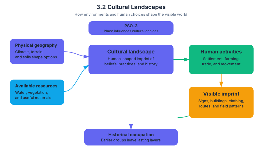
The key relationship is expressed by PSO-3: “Cultural practices vary across geographical locations because of physical geography and available resources.” Physical geography does not mechanically determine culture, but climate, terrain, soils, vegetation, and available resources influence the choices people can make. Human activities then modify those environments, creating landscapes that reflect both environmental conditions and cultural decisions.
Natural landscape versus cultural landscape
A physical or natural landscape consists primarily of environmental features such as mountains, rivers, climate, soils, and natural vegetation. A cultural landscape includes the changes people make to that setting: buildings, roads, farms, signs, religious structures, grazing routes, resource-management systems, and places named or shaped by human groups.
The distinction is analytical rather than absolute. A dry Sahelian environment is a physical landscape; wells, livestock corridors, seasonal settlements, corrals, markets, and communication towers created or used by pastoral groups are cultural-landscape elements within it.
| Landscape element | What it reveals | Examples |
|---|---|---|
| Visual | Identity and history made visible | Art, architecture, clothing, signs, place names, older buildings |
| Intangible | Beliefs and social organization | Religion, language, governance, gender or ethnic attitudes |
| Functional | How people use and manage space | Land-use patterns, agricultural styles, grazing systems |
| Historical | Earlier cultural layers | Abandoned settlements, reused buildings, older roads or toponyms |
Placemaking and ethnic traditions
Placemaking is the process through which people give a location meaning and make it express a shared identity. Regional patterns of language, religion, and ethnicity contribute to a sense of place, enhance placemaking, and shape the global cultural landscape (PSO-3.D.1). In other words, culture does not merely occupy space; it helps produce recognizable places.
Immigrants may preserve ethnic traditions through placemaking. Traditional architecture, bilingual or heritage-language signs, restaurants, religious buildings, festivals, and culturally meaningful toponyms can mark an ethnic neighborhood. These features do not prove that every resident shares the same identity, but they show how cultural practices remain visible after migration.
Misconception check: A cultural landscape is not limited to old or rural places. A recently developed immigrant neighborhood, a modern religious center, or a bilingual commercial district is also a cultural landscape.
Sequent occupance: landscapes as layered records
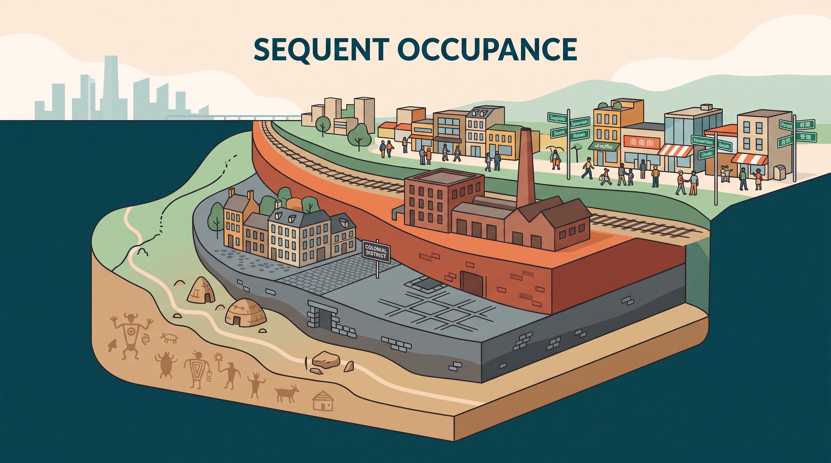
Sequent occupance means that successive groups occupy and modify the same place, leaving behind overlapping cultural layers. A city may contain an older Indigenous place name, a colonial street grid, a later religious building, industrial structures, and contemporary multilingual signs. The landscape becomes a historical record—not a frozen snapshot of one culture.
Worked example: pastoral nomadism in the Sahel
The Sahel is a semi-arid transition region south of the Sahara. Pastoral nomadism, a livelihood based on moving livestock between grazing areas, affects its cultural landscape through both land use and cultural identity.
Step 1 — Physical setting: Natural drought, increasingly dry conditions, and climate change can reduce vegetation and soil moisture. Runoff, wind, and erosion may remove fertile topsoil. Population growth, cultivation of arid land, demand for water, and the use of wood for fuel or building materials can place additional stress on scrub and shrub landscapes.
Step 2 — Cultural adaptation: Herders follow established migration routes to reach seasonal pasture and water. Their movement creates recognizable land-use patterns, including watering sites, market locations, animal pens, corrals, and temporary settlements.
Step 3 — Cultural meaning: Portable or seasonal dwellings, livestock practices, dairying traditions, celebrations, meeting places, and even communication infrastructure such as cell-phone towers reflect the identities and needs of mobile groups. Thus, pastoral nomadism leaves both functional and symbolic marks on the landscape.
Step 4 — Environmental interaction: Grazing can be sustainable when movement allows vegetation to recover, but concentrated grazing, wood removal, drought, and erosion can contribute to land degradation. The strongest explanation connects the activity to a landscape outcome: pastoral mobility shapes routes and settlements, while environmental stress can reduce the vegetation supporting that system.
AP skill connection
This topic most directly develops Skill Category 1: Concepts and Processes, especially 1.A Describe spatial patterns and processes and 1.B Explain spatial concepts. It also uses Skill Category 2: Spatial Relationships, including 2.A Describe spatial relationships across different scales and 2.B Explain spatial relationships across different scales, because cultural landscapes connect household practices, local places, regional environments, and global migration.
For source-based work, apply Skill Category 4: Source Analysis, especially 4.A Identify information from geographic sources and 4.B Explain spatial relationships in geographic sources. Under Skill Category 5: Scale Analysis, 5.A Identify the scales of analysis presented by geographic data helps distinguish a neighborhood’s cultural signs from a regional pattern of language or religion.
Retrieval check
A landscape contains bilingual signs, a heritage-style religious building, an older colonial street name, and a modern transit station. Identify one visual cultural element, one example of sequent occupance, and one way placemaking could strengthen ethnic identity. Then explain how the answer would differ if the question asked about the physical landscape rather than the cultural landscape.
Source Materials
- AP Human Geography Course and Exam Description
- AP Human Geography Course and Exam Description Clarifications and Corrections
- AP Human Geography Course Overview
- AP Human Geography Course at a Glance
- AP Human Geography Course at a Glance Poster
- AP Human Geography
- AP Human Geography
- AP Human Geography Sample Syllabus 1