From the free course AP Human Geography on Lykke
1.6 Scales of Analysis
Key concepts: scales of analysis · spatial patterns · relationships among places · supranational organizations · shared decision-making · state sovereignty · regional scale · national scale · agglomerations · specific infrastructure and locations
A map can show an entire country while hiding the places, infrastructures, and relationships that make the country function. Scale of analysis is the geographic level—global, regional, national, or local—at which a pattern or process is examined.
1.6 Scales of Analysis
A map can show an entire country while hiding the places, infrastructures, and relationships that make the country function. Scale of analysis is the geographic level—global, regional, national, or local—at which a pattern or process is examined.
PSO-1: Geographers analyze relationships among and between places to reveal important spatial patterns.
The central question is not simply “What does the map show?” but “What becomes visible or invisible when the geographic viewpoint changes?” A pattern that appears clear at one scale may weaken, disappear, or receive an entirely different interpretation at another.
The four scales of analysis
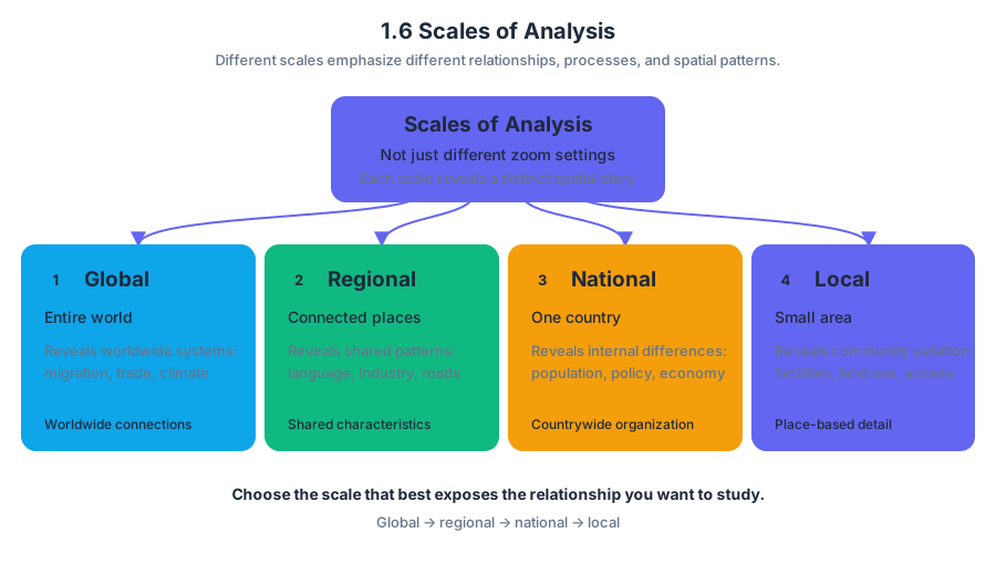
EK PSO-1.C.1: Scales of analysis include global, regional, national, and local. These scales are not merely different zoom settings; each emphasizes different relationships, processes, and spatial patterns.
| Scale | Geographic focus | Patterns it can reveal |
|---|---|---|
| Global | The entire world or worldwide systems | Global migration flows, international trade, climate patterns |
| Regional | A group of places sharing a connection or characteristic | Industrial specialization, language patterns, or regional infrastructure |
| National | A single country and its internal organization | National population distribution, state policies, or countrywide economic differences |
| Local | A city, neighborhood, campus, or small area | Specific facilities, land uses, accessibility, and community-level variation |
The word regional does not automatically mean “small,” and national does not automatically mean “more accurate.” The appropriate scale depends on the question. A global map is useful for comparing continents, but it cannot explain why one neighborhood has better access to public transportation than another.
What changing scale reveals—and conceals
LO PSO-1.C: Define scales of analysis used by geographers.
LO PSO-1.D: Explain what scales of analysis reveal.
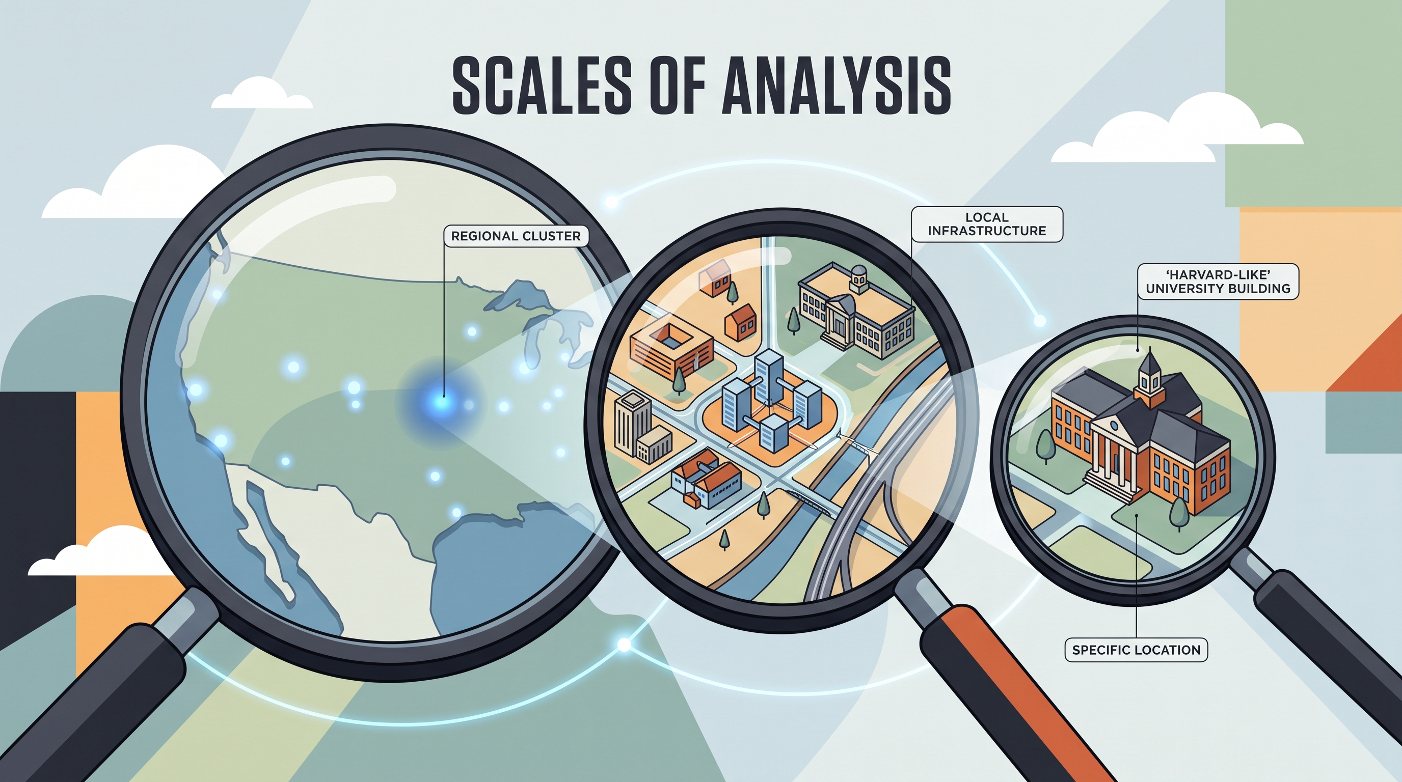
EK PSO-1.D.1: Patterns and processes at different scales reveal variations in, and different interpretations of, data. At a broad national scale, a map may show the location of an entire city, but it may conceal the agglomerations and specific infrastructure within that city. An agglomeration is a concentration of related activities or facilities in one place.
Consider the Boston area:
- A national-scale map of the United States might identify Boston as a major city.
- A regional-scale map of eastern Massachusetts could show Cambridge, university districts, transportation routes, and clusters of research institutions.
- A local-scale map could identify the precise location of Harvard University, individual streets, or nearby land uses.
The information has not necessarily become “better” as the scale changes; it has become more appropriate for a different question. A national map supports a claim about Boston’s position within the United States. It cannot, by itself, support a claim about the location of Harvard University or the distribution of research infrastructure inside the Boston region.
Scale and spatial relationships
Geographers use scale to analyze relationships among and between places. For example, a local concentration of technology firms may be connected to regional universities, national investment policies, and global networks of finance and information. Each scale contributes evidence, but no single scale explains the complete pattern.
This is why geographic conclusions must match the scale of the evidence. A regional map may show that one region specializes in a particular type of production, but it cannot automatically justify a conclusion about every region in the country. Other regions may have different economic sectors, infrastructure, or environmental conditions.
Scale-transfer warning: Using evidence from one scale to make a claim about another scale can produce an inaccurate conclusion or an ecological fallacy—the error of assuming that a pattern for a group applies equally to every smaller place within it.
Supranational organizations and sovereignty
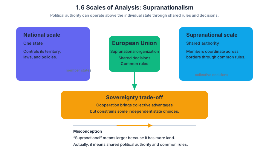
Scale also applies to political decision-making. A supranational organization is an organization in which member states cooperate through shared decision-making and common rules. This creates a level of governance above the individual state.
The European Union illustrates this relationship. Member states remain states, but membership can constrain their independent choices in areas such as trade and governance. Common rules may coordinate markets, regulate economic activity, or establish shared policies. In exchange for cooperation and collective advantages, each member gives up some degree of individual state sovereignty, meaning the state’s authority to control its internal affairs and external relations independently.
Supranationalism therefore creates a tension between two geographic scales:
- National scale: A state seeks authority over its own territory, laws, and policies.
- Supranational scale: Member states share authority to address challenges and coordinate rules across borders.
Named misconception — “Supranational” means larger because it has more land.
The term refers to shared political authority, not physical size. A supranational organization constrains member states because decisions are made collectively and common rules apply across participating countries.
Worked interpretation
Suppose a map at the regional scale shows high concentrations of technology employment around Boston and Cambridge. A strong interpretation would describe the visible regional pattern and connect it to local universities, transportation, and research infrastructure. A weak interpretation would claim that all of the United States has the same concentration simply because the regional map shows one important technology cluster.
Retrieval check: A national-scale map shows Boston but not Harvard University. Which scale would better reveal Harvard’s precise location and its relationship to nearby infrastructure? Why would it be risky to use that regional or local evidence to describe every city in the United States?
Source Materials
- AP Human Geography Course and Exam Description
- AP Human Geography Course and Exam Description Clarifications and Corrections
- AP Human Geography Course Overview
- AP Human Geography Course at a Glance
- AP Human Geography Course at a Glance Poster
- AP Human Geography
- AP Human Geography
- AP Human Geography Sample Syllabus 1