From the free course AP Human Geography on Lykke
6.5 The Internal Structure of Cities
Key concepts: Internal structure of cities · Urban models and theories · Burgess concentric-zone model · Hoyt sector model · Harris and Ullman multiple-nuclei model · Physical geography and resources · Geographic variation in cities · Limitations of urban models · Quantitative urban data · Qualitative urban data
A city is not internally uniform: housing, industry, commerce, transportation, and government occupy different spaces because land values, accessibility, physical geography, historical development, and environmental resources vary across the urban area.
6.5 The Internal Structure of Cities
A city is not internally uniform: housing, industry, commerce, transportation, and government occupy different spaces because land values, accessibility, physical geography, historical development, and environmental resources vary across the urban area.
A useful mental image is a city as a set of magnets competing for space. A downtown business district pulls offices and retail toward highly accessible land; factories seek transportation routes and room to expand; households balance land cost against commuting time; and natural features such as rivers, mountains, coastlines, and floodplains constrain the possible arrangement.
LEARNING OBJECTIVE (PSO-6.D): Explain the internal structure of cities using various models and theories.
ESSENTIAL KNOWLEDGE (PSO-6.D.1): Models and theories that are useful for explaining internal structures of cities include the Burgess concentric-zone model, the Hoyt sector model, the Harris and Ullman multiple-nuclei model, the galactic city model, bid-rent theory, and urban models drawn from Latin America, Southeast Asia, and Africa.
Urban models: useful patterns, not perfect maps
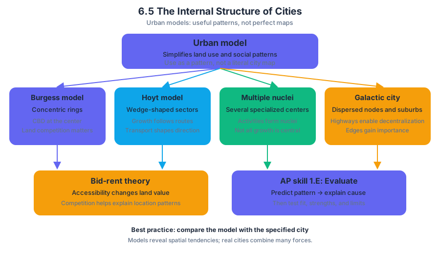
An urban model is a simplified representation of how land uses and social groups are arranged within a city. Models help geographers identify spatial patterns and propose explanations, but they are not literal maps of every city.
The central AP skill is 1.E: Explain the strengths, weaknesses, and limitations of different geographic models and theories in a specified context. A strong explanation does more than name a model: it identifies the pattern the model predicts, connects that pattern to a cause, and then evaluates whether the specified city actually fits.
| Model or theory | Main predicted pattern | Important explanatory idea |
|---|---|---|
| Burgess concentric-zone model | Rings surrounding a central business district | Distance from the center and competition for land |
| Hoyt sector model | Wedges or corridors extending from the center | Transportation routes and directional growth |
| Harris and Ullman multiple-nuclei model | Several specialized centers | Distinct activities develop around separate nuclei |
| Galactic city model | A dispersed metropolitan area with peripheral nodes | Highways, suburbs, and edge-centered development |
| Bid-rent theory | Land value changes with accessibility and permitted use | Different users can pay different amounts for accessible land |
| Regional urban models | Distinct patterns associated with Latin America, Southeast Asia, or Africa | Local history, colonialism, informality, culture, and uneven development |
Burgess concentric-zone model
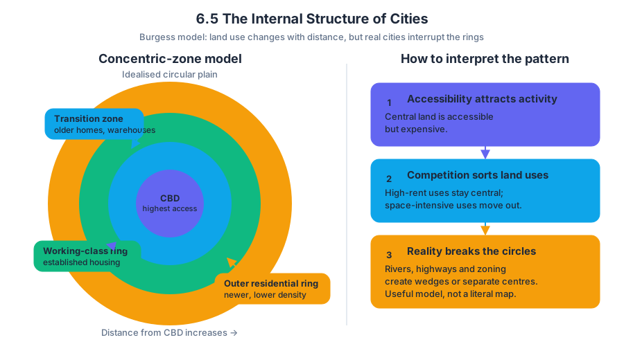
The Burgess concentric-zone model represents the city as a series of rings expanding outward from the central business district, or CBD, where commercial activity and accessibility are greatest. In the classic model, the inner rings contain zones of transition and lower-income housing, while more affluent residential areas occur farther from the center.
The model’s mechanism is competition. Because central land is accessible but expensive, businesses and residents compete for it; land uses that need maximum accessibility can justify high rents, while activities needing more space may relocate outward. As the city grows, redevelopment and filtering can produce changing rings of land use.
Worked interpretation: Suppose a city’s CBD occupies the center of a circular plain. A ring immediately outside it contains older apartments, warehouses, and recently arrived migrants; a second ring contains established working-class housing; and a third ring contains newer, lower-density housing. This arrangement broadly resembles Burgess because land use changes with distance from the center.
Its limitation is equally important: real cities are rarely circular. Rivers, coastlines, highways, zoning laws, suburban employment centers, and historic boundaries interrupt rings. A city with a major industrial corridor may show a wedge rather than a complete ring.
Hoyt sector model
The Hoyt sector model modifies the ring pattern by showing urban land uses as wedges, or sectors, radiating outward from the CBD. High-income housing, low-income housing, and industry may extend along particular transportation routes rather than forming complete circles.
Transportation creates the model’s directional logic. Railways, highways, ports, and major roads increase accessibility along a corridor, encouraging factories, warehouses, or commercial development to grow outward in that direction. Residential sectors may then follow the same corridor or avoid it, depending on environmental quality and land prices.
Example: If a railway leaves a CBD toward the southwest, industrial land may form a southwest wedge. If the city’s cleanest and highest ground lies northeast, affluent residential development may extend northeast instead of appearing evenly around the center.
Harris and Ullman multiple-nuclei model
The Harris and Ullman multiple-nuclei model explains cities as systems containing several centers, or nuclei, rather than one dominant CBD. A university district, airport, industrial park, suburban shopping center, medical complex, or government center can each attract related activities.
The model reflects modern metropolitan growth, in which people may travel between suburban employment centers without passing through downtown. Certain land uses cluster because they benefit from one another, while others separate because they conflict: heavy industry may seek rail access but avoid expensive office districts, and airports require large sites away from dense residential areas.
Strength: the model can explain polycentric metropolitan regions better than a single-center model. Limitation: it may describe the pattern without identifying which nucleus appeared first, how powerful each nucleus is, or how physical barriers and public policy shaped its location.
Galactic city, bid-rent theory, and regional models
The galactic city model, also called the peripheral model, describes a dispersed metropolitan area in which suburban activity centers and transportation nodes surround or connect to the older core. Edge cities near highway interchanges may contain offices, retail, hotels, and entertainment, reducing dependence on the historic CBD.
Bid-rent theory explains why different users occupy different locations by focusing on the maximum rent each user is willing and able to pay. Highly accessible land near the CBD often has high commercial value, while households or industries may choose locations farther away if they need larger sites or can tolerate longer travel distances. The theory predicts a relationship, not a guaranteed land-use map.
Regional models are essential because cities develop through different historical and cultural processes. Urban models drawn from Latin America, Southeast Asia, and Africa may account for colonial planning, informal settlements, rapid migration, mixed land uses, unequal infrastructure, and the continuing influence of indigenous or local urban forms. Applying a model developed from one region uncritically to another can hide rather than explain urban reality.
Physical geography and resources
The presence and growth of cities vary across geographical locations because of physical geography and resources. Harbors support port functions; rivers can provide transportation and water but also create flood risk; mountains constrain expansion; fertile plains support food production; and mineral or energy resources can attract specialized industries.
Physical geography does not mechanically determine urban form. Human decisions, technology, infrastructure, zoning, investment, and political power can overcome some constraints or intensify others. A city may build tunnels through mountains, elevate roads above floodplains, or redirect growth toward safer land—but these choices have costs.
Investigating internal structure with evidence
Geographers combine quantitative data and qualitative information to investigate internal structure. Quantitative evidence might include population density, land values, commuting flows, building heights, household income, or the percentage of land devoted to different uses. Qualitative evidence might include interviews, field observations, planning documents, photographs, and residents’ descriptions of neighborhood change.
Worked contextual example: Imagine that land-value data show the highest prices in the CBD and along two rail corridors, while a map of employment shows three major clusters: downtown offices, an airport logistics zone, and a suburban technology center. Field observations also find informal housing near industrial land and newer affluent housing near a protected hillside.
The evidence supports a combination of models rather than one perfect fit. The CBD and rail corridors resemble the Burgess and Hoyt models; the airport and technology center support the multiple-nuclei and galactic city models; and the hillside and protected land demonstrate how physical geography and regulation redirect growth. The correct conclusion is not “the city is a Burgess city,” but “different models explain different parts of its internal structure.”
Misconception check
Named misconception: “Urban models are exact predictions.” They are not. A model is useful when it explains a significant pattern in a specified context, even if other forces produce exceptions. On an exam, evaluate the fit: identify supporting evidence, name a contradiction, and explain the geographic process causing the difference.
Retrieval check
A city has one historic CBD, industrial development concentrated beside a railroad, and two large suburban employment centers near highway interchanges. Which model or combination of models best explains the pattern, and what evidence would you use to test it? A strong answer should connect the railroad to the Hoyt sector model, the suburban centers to the Harris and Ullman multiple-nuclei model or galactic city model, and the evidence to measurable land use, accessibility, and employment data.
Source Materials
- AP Human Geography Course and Exam Description
- AP Human Geography Course and Exam Description Clarifications and Corrections
- AP Human Geography Course Overview
- AP Human Geography Course at a Glance
- AP Human Geography Course at a Glance Poster
- AP Human Geography
- AP Human Geography
- AP Human Geography Sample Syllabus 1