From the free course AP Human Geography on Lykke
5.8 Von Thünen Model
Key concepts: Von Thünen model · Scale analysis · Geographic scales · Rural land use · Transportation costs · Distance from the market · Concentric rings · Regions of specialty farming · Spatial relationships · Geographic models and theories
A farm’s location can matter almost as much as its soil: perishable or bulky products usually become less profitable as they travel farther from the market.
5.8 Von Thünen Model
A farm’s location can matter almost as much as its soil: perishable or bulky products usually become less profitable as they travel farther from the market. The Von Thünen model explains this rural land-use pattern by connecting agricultural location to transportation costs and distance from the market.
Learning Objective PSO-5.D: Describe how the von Thünen model is used to explain patterns of agricultural production at various scales.
Essential Knowledge PSO-5.D.1: Von Thünen’s model helps explain rural land use by emphasizing the importance of transportation costs associated with distance from the market; however, regions of specialty farming do not always conform to von Thünen’s concentric rings.
The model’s central logic
Imagine a single city surrounded by agricultural land. A farmer near the city can deliver milk, vegetables, or flowers quickly, while a farmer farther away must spend more money transporting products. If the product is perishable, fragile, or expensive to move, proximity to the market becomes especially valuable.
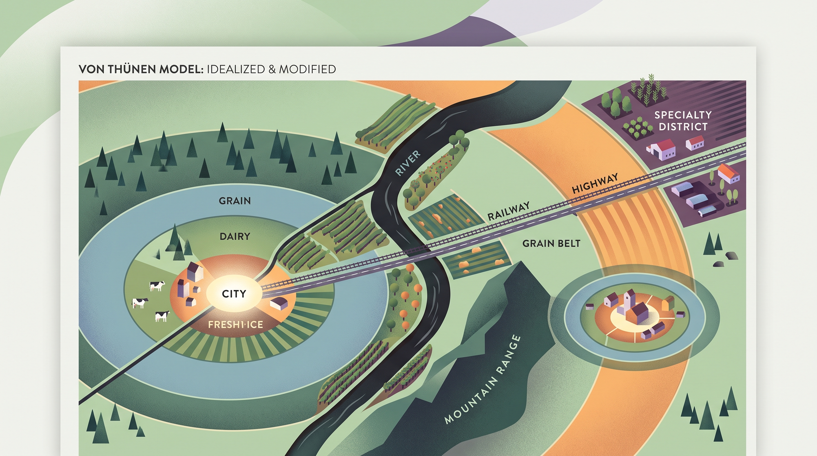
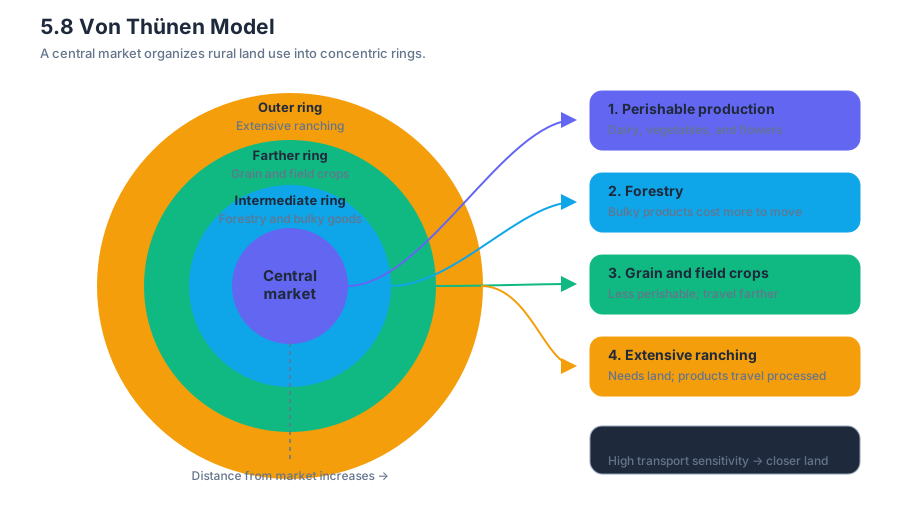
The model represents rural land-use patterns as concentric rings around a central market. A concentric ring is a circular zone sharing the same center. In the simplified model, land uses requiring high market access tend to occupy the inner rings, while less perishable or less transport-sensitive activities can occur farther out.
| Distance from central market | Expected land use in the simplified model | Why it fits |
|---|---|---|
| Closest ring | Intensive gardening, dairy, or other perishable production | Products must reach consumers quickly; land rents near the market are high |
| Intermediate rings | Forestry or other bulky products | Transport costs matter because the products are heavy or expensive to move |
| Farther rings | Grain or field crops | Products are less perishable and can tolerate longer travel |
| Outermost ring | Extensive ranching or livestock production | Large areas of land are needed, and products can travel after processing |
These rings are not a prediction that every landscape will display perfect circles. They are a geographic model: a simplified representation used to identify and explain spatial patterns. Its value lies in making the relationship between market distance and land use visible.
Worked example: applying the model
Suppose a municipality contains four farming zones around a major food market. Zone A produces fresh lettuce, Zone B produces timber, Zone C grows wheat, and Zone D raises cattle on large grazing areas.
Step 1 — Identify the controlling factor. Distance from the market affects transportation costs.
Step 2 — Rank transport sensitivity. Lettuce is highly perishable; timber is bulky; wheat is comparatively durable; cattle ranching requires extensive land.
Step 3 — Match land uses to distance. The model would place lettuce closest to the market, timber next, wheat farther away, and ranching farthest away.
Step 4 — Explain the pattern geographically. The expected pattern results from the interaction of transportation costs, product characteristics, land value, and distance from the market—not simply from climate or soil.
Scale analysis: the key AP skill
Scale analysis examines how a geographic pattern changes when the size of the study area changes. Geographic scale may be global, regional, national, or local. A local-scale study area might be a neighborhood or municipality; a regional study area might include several municipalities and their shared market system.
The Von Thünen model should therefore be applied across scales rather than treated as a single fixed map.
- At the local scale, the model might explain why vegetable farms cluster near a municipal food market.
- At the regional scale, several cities may create overlapping market areas, producing a more complex pattern than one set of rings.
- At the national scale, transportation networks, national demand, and regional specialization may matter more than distance from one central market.
- At the global scale, refrigerated shipping and international trade can connect distant producers to consumers, weakening the original distance-based pattern.
The associated AP skills are 5.B — Describe spatial patterns and processes at different scales and 5.D — Explain how concepts, processes, and models are used across geographic scales. A strong explanation does more than name a ring: it states the scale, identifies the spatial relationship, and explains why the relationship changes—or remains visible—at that scale.
Strengths, limitations, and change over time
The model’s major strength is explanatory clarity. It helps identify patterns in rural land use by showing how transportation costs and market distance can organize agricultural production. It also gives students a structure for comparing places and asking why a real landscape resembles—or differs from—the ideal pattern.
Its limitations are equally important. The original model assumes a single central market, uniform physical geography, equal transportation access, and similar economic decision-making across the landscape. Real regions contain multiple markets, highways, railways, mountains, differing land values, government policies, and cultural preferences.
Specialty farming is a particularly important exception. A region may specialize in a crop because of a distinctive climate, cultural tradition, technology, or established market, even when that region lies far from the expected position in the concentric rings. The model identifies a tendency, not an unbreakable rule.
The assumptions and patterns may also change over time. Refrigeration, faster transportation, improved roads, online marketplaces, and changing consumer demand can reduce the penalty of distance. A pattern that fit the model in one period may become weaker or reorganized in another.
Misconception check and retrieval
Named misconception: “The Von Thünen model says all farms must form perfect circles.” Correction: the concentric rings are an idealized pattern. Use them as a starting point, then explain deviations through specialty farming, multiple markets, infrastructure, physical geography, and technological change.
Retrieval check: A distant region grows a high-value specialty crop despite high transportation costs. Which part of the model does this challenge, and what geographic factors could explain the exception? A complete answer should identify the distance-cost expectation, then explain how specialization, environment, culture, technology, or market demand can produce a different spatial pattern.
Source Materials
- AP Human Geography Course and Exam Description
- AP Human Geography Course and Exam Description Clarifications and Corrections
- AP Human Geography Course Overview
- AP Human Geography Course at a Glance
- AP Human Geography Course at a Glance Poster
- AP Human Geography
- AP Human Geography
- AP Human Geography Sample Syllabus 1