From the free course AP Human Geography on Lykke
5.2 Settlement Patterns and Survey Methods
Key concepts: Rural settlement patterns · Clustered settlements · Dispersed settlements · Linear settlements · Metes-and-bounds surveying · Township-and-range surveying · Long-lot surveying · Rural land-use patterns · Agricultural practices and resource availability · Visual source analysis
A rural landscape is not randomly assembled: the way homes, fields, roads, and water are arranged reveals how people use resources, move across space, and organize land ownership.
5.2 Settlement Patterns and Survey Methods
A rural landscape is not randomly assembled: the way homes, fields, roads, and water are arranged reveals how people use resources, move across space, and organize land ownership. Rural settlement patterns describe the visible arrangement of buildings and farmsteads, while survey methods describe the system used to divide and record the land itself.
Enduring Understanding PSO-5: Availability of resources and cultural practices influence agricultural practices and land-use patterns.
Learning Objective PSO-5.B: Identify different rural settlement patterns and methods of surveying rural settlements.
Essential Knowledge
- PSO-5.B.1: Specific agricultural practices shape different rural land-use patterns.
- PSO-5.B.2: Rural settlement patterns are classified as clustered, dispersed, or linear.
- PSO-5.B.3: Rural survey methods include metes and bounds, township and range, and long lot.
Reading the rural landscape
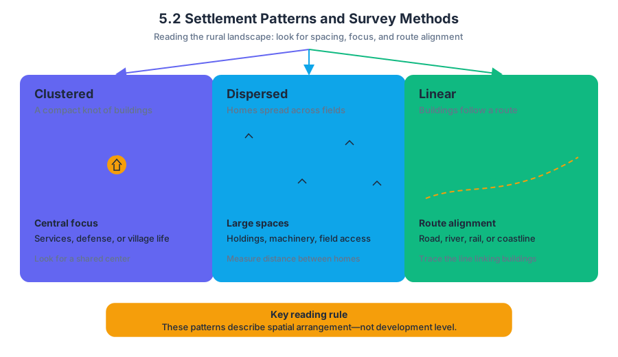
Imagine looking down from an airplane. If houses form a compact knot around a church, crossroads, or village green, the settlement is clustered. If each farmhouse sits among its own fields with large spaces between homes, it is dispersed. If buildings form a narrow chain beside a river, road, railway, or coastline, the settlement is linear.
| Pattern | What the buildings look like | Why it may develop |
|---|---|---|
| Clustered | Buildings grouped around a central settlement area | Shared services, defensive needs, community institutions, or a tradition of village living |
| Dispersed | Homes and farmsteads spread across the landscape | Large individual holdings, mechanized farming, or a preference for living near one’s fields |
| Linear | Buildings arranged in a line | Access to roads, rivers, coastlines, railways, or other transportation routes |
These categories describe spatial arrangement, not levels of development. A clustered settlement is not automatically older or poorer than a dispersed settlement, and a linear settlement is not simply “a town that happens to be long.” The key evidence is the relationship between buildings and the physical or transportation feature guiding their placement.
Clustered settlements
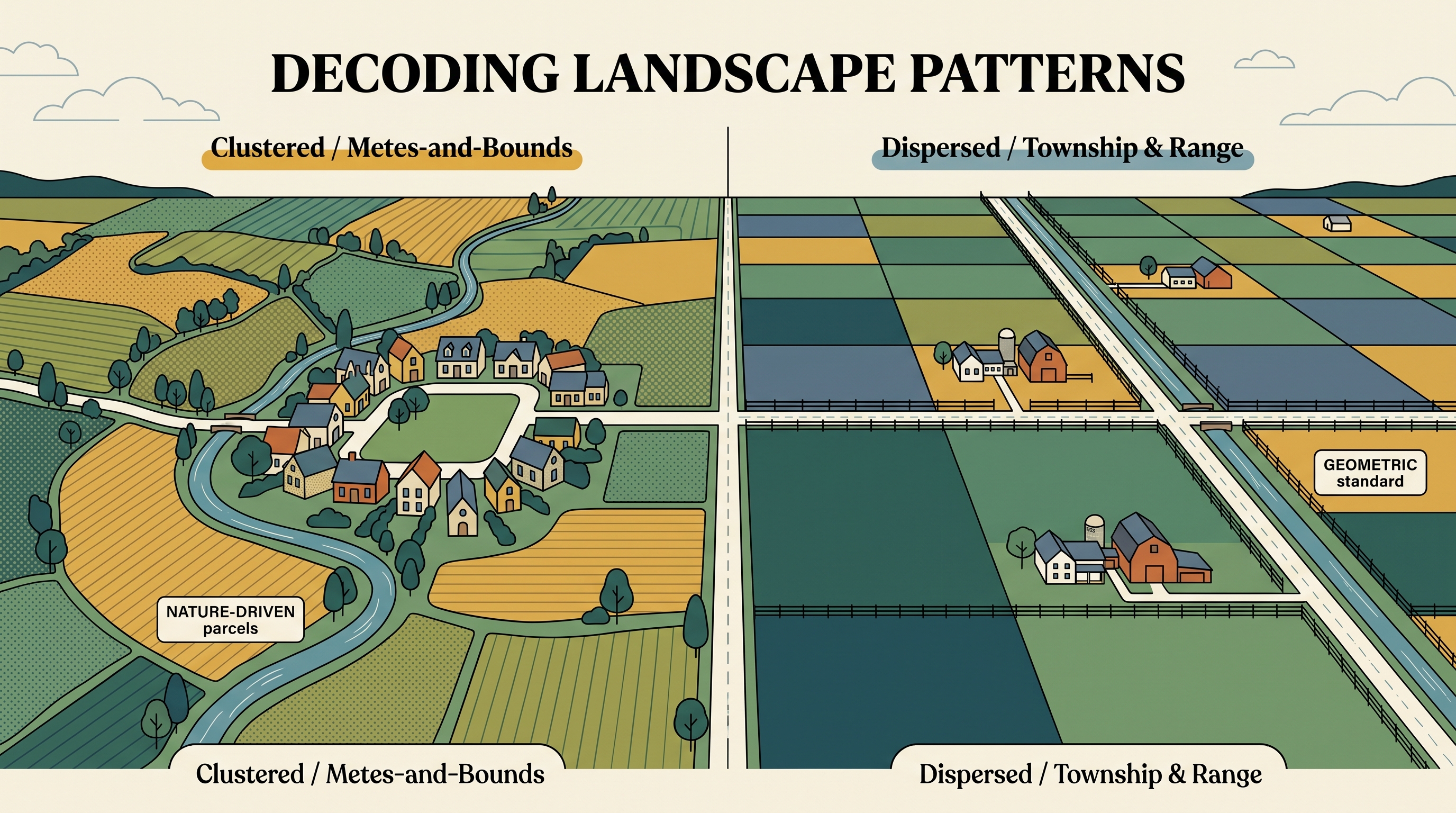
In a clustered settlement, buildings are grouped together around a central settlement area. This arrangement can make shared institutions—such as a market, school, religious building, or water source—more accessible. Fields may extend outward from the settlement, creating a clear contrast between a compact residential core and surrounding agricultural land.
Dispersed settlements
In a dispersed settlement, homes and farmsteads are spread across the landscape rather than concentrated in one village. This pattern commonly corresponds to agricultural systems in which households occupy or work separate parcels, especially where land is abundant or farms require substantial space.
Linear settlements
Linear settlements develop along roads, rivers, coastlines, or other transportation routes. The route provides movement, access to markets, water, or transportation, while the settlement’s narrow shape reflects the directional constraint of that feature. A row of farms beside a river is therefore linear even if the individual farmsteads are widely spaced.
Survey systems: the geometry of ownership
A settlement pattern tells you where people live; a survey system tells you how parcels were measured and bounded. Three systems are especially important: metes-and-bounds, township-and-range, and long lot.
Metes-and-bounds surveying uses physical features, distances, and directions to define irregular parcels. A boundary might follow a stream, then run a specified distance north, turn toward a large oak tree, and continue along a ridge. Because the boundaries follow local landmarks rather than a universal grid, parcels often have uneven shapes.
The township-and-range system organizes land into a rectangular grid. A large area is divided into townships, and each township is divided into regularly shaped sections. This creates a landscape of straight roads, right-angle property lines, and rectangular fields—an immediately recognizable visual signature.
The long-lot system divides land into narrow, elongated parcels. These parcels commonly extend from a settlement or transportation route to a waterway, giving each household access to both movement and water. On a map, long lots appear as thin strips running perpendicular to a river, road, or coast.
Worked visual analysis
Suppose a map shows thirty farmhouses concentrated around a small church, with fields radiating outward. A second map shows isolated farmsteads surrounded by separate fields. A third shows narrow parcels stretching from a road back to a river.
Step 1 — Identify the settlement pattern. The first map is clustered because buildings gather around a central place. The second is dispersed because farmsteads are spread across the landscape. The third is likely linear if the buildings follow the road or river.
Step 2 — Identify the survey system. If the first map contains irregular boundaries following streams and hills, it suggests metes-and-bounds. If the second contains a regular checkerboard of rectangles, it suggests township-and-range. If the third contains narrow strips running between a route and waterway, it suggests the long-lot system.
Step 3 — Explain the relationship. Do not stop at naming the pattern. Connect it to resources and cultural practices: water access can produce long lots; large farms and mechanized agriculture can encourage dispersed settlement; shared services or traditional village organization can support clustered settlement.
Misconception check
Common misconception: “Settlement pattern and survey system mean the same thing.”
They do not. A clustered settlement may exist on irregular metes-and-bounds parcels, and a dispersed settlement may occur within a rectangular township-and-range grid. Settlement pattern concerns the distribution of buildings; surveying concerns the shape and organization of land parcels.
AP skill in action
Suggested Skill 4.D — Source Analysis: Compare patterns and trends in visual sources to draw conclusions. On an exam, compare visual evidence before explaining it. Look for clustering, spacing, alignment, parcel shape, straight versus irregular boundaries, and the physical feature—if any—that organizes the landscape. Then draw a conclusion supported by both the observed pattern and a geographic cause.
Retrieval check: A map shows houses in a compact group, irregular property boundaries following streams, and fields surrounding the village. Identify the settlement pattern and survey system, then give one resource or cultural factor that could help explain the arrangement.
Answer: The settlement is clustered because the buildings are grouped around a central area. The survey system is metes-and-bounds because boundaries follow physical features and form irregular parcels. Shared services, community traditions, or access to a common water source could help explain the pattern.

Source Materials
- AP Human Geography Course and Exam Description
- AP Human Geography Course and Exam Description Clarifications and Corrections
- AP Human Geography Course Overview
- AP Human Geography Course at a Glance
- AP Human Geography Course at a Glance Poster
- AP Human Geography
- AP Human Geography
- AP Human Geography Sample Syllabus 1
- 2. Country X and Country Y have a long-established trade relationship in agricultural products.