From the free course AP Environmental Science on Lykke
4.7 Solar Radiation and Earth’s Seasons · 4.8 Earth’s Geography and Climate
Key concepts: Incoming solar radiation (insolation) · Relationship between solar radiation, season, and latitude · Solar-ray angle and radiation intensity · Earth’s axial tilt and seasons · Earth’s geography · Weather and climate · Geologic factors affecting weather and climate · Geographic factors affecting weather and climate · Atmospheric circulation · Global wind patterns and equatorial solar radiation
Earth’s surface is heated unevenly because sunlight arrives at different angles, for different lengths of time, at different latitudes and seasons. That uneven heating drives temperature differences, while Earth’s landforms and geographic position reshape the resulting weather and climate.
4.7 Solar Radiation and Earth’s Seasons · 4.8 Earth’s Geography and Climate
Earth’s surface is heated unevenly because sunlight arrives at different angles, for different lengths of time, at different latitudes and seasons. That uneven heating drives temperature differences, while Earth’s landforms and geographic position reshape the resulting weather and climate.
Insolation: the energy arriving from the Sun
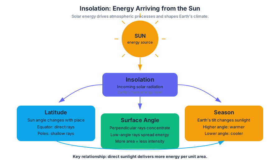
Insolation means incoming solar radiation—the Sun’s energy received by Earth. It is Earth’s main source of energy, and the amount received at a location depends primarily on latitude and season. This relationship is captured by ENG-2.A.1 under the enduring understanding ENG-2: most atmospheric processes are driven by energy input from the Sun.
The same beam of sunlight can warm two surfaces very differently. When rays strike nearly perpendicular to the surface, their energy is concentrated in a smaller area. When rays arrive at a low angle, the same energy spreads across a larger area and is therefore less intense per unit area.
This geometric effect explains why the highest solar radiation per unit area occurs near the equator and generally decreases toward the poles (ENG-2.A.2 and ENG-2.A.3). Earth’s curved shape causes equatorial surfaces to face incoming radiation more directly, while polar surfaces receive sunlight at a shallower angle.
Key relationship: A more direct solar angle concentrates energy; a lower solar angle spreads energy out.
Why Earth has seasons
Earth’s axis is tilted relative to its orbit around the Sun. This axial tilt causes both the seasons and changes in the number of daylight hours at a location, as required by ENG-2.A.5. Seasons are not caused primarily by Earth being much closer to or farther from the Sun.
When a hemisphere tilts toward the Sun, it receives more direct radiation and longer periods of daylight. The combination produces greater daily energy input and summer conditions. When that hemisphere tilts away from the Sun, it receives lower-angle radiation and shorter daylight, producing winter conditions. Therefore, a location receives its greatest solar radiation during its longest summer day and its least during its shortest winter day (ENG-2.A.4).
Worked example: Consider a city at $40^\circ$ north latitude. In its summer, the Northern Hemisphere tilts toward the Sun. The Sun appears higher in the sky, its rays strike the city more directly, and daylight lasts longer. In winter, the Sun’s rays arrive at a lower angle and daylight is shorter, so the city receives less solar energy per day. The explanation uses three linked observations: axial tilt → solar angle and day length → seasonal insolation.
From uneven heating to atmospheric circulation
Unequal insolation creates temperature differences across Earth’s surface. Air warmed more strongly near the equator expands, becomes less dense, and rises; cooler, denser air sinks elsewhere. These density differences establish pressure differences and help produce large-scale atmospheric circulation. Global wind patterns primarily originate from the intense solar radiation received near the equator, with Earth’s rotation and the Coriolis effect modifying the flow (ERT-4.E.1).
The required learning objective ENG-2.A, “Explain how the sun’s energy affects the Earth’s surface,” is therefore not merely about temperature. It requires tracing energy from sunlight to uneven surface heating, then to differences in air density, pressure, and atmospheric movement. When interpreting a circulation diagram, apply Suggested Skill 2.B: Visual Representations by explaining how the visual characteristics—such as latitude, arrows, temperature zones, or rising air—relate to one another.
Geography and geology reshape climate
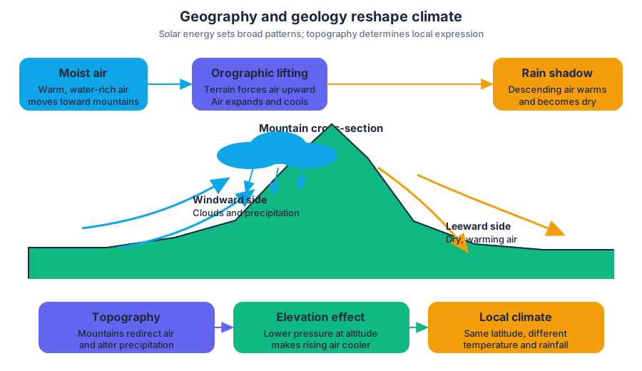
Solar energy establishes broad patterns, but Earth’s geography determines how those patterns are expressed locally. Geologic factors include the physical structure of Earth’s surface, especially topography—the arrangement and elevation of landforms. Mountains, mountain ranges, plateaus, valleys, and elevation can redirect air, alter precipitation, and change temperature.
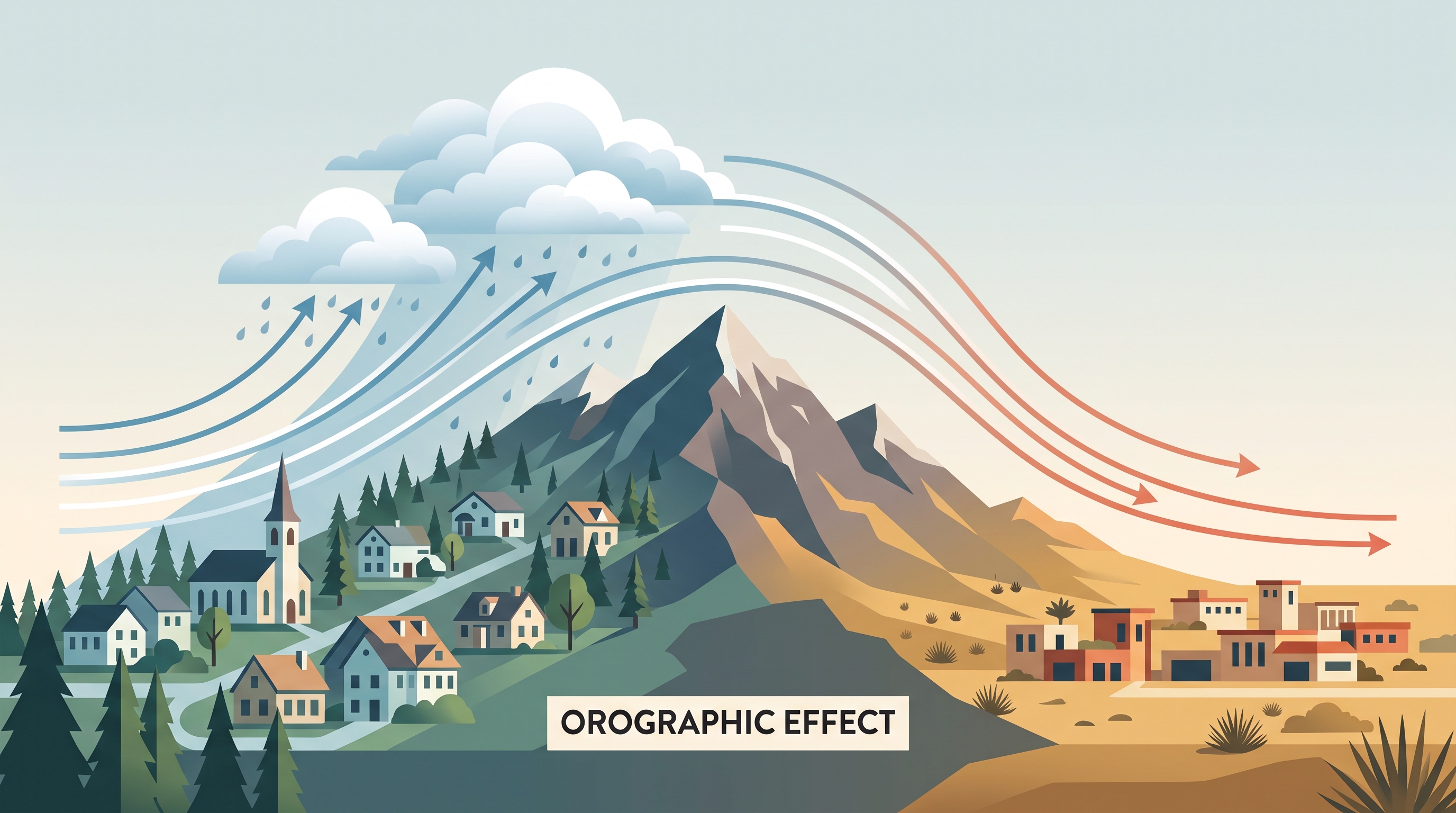
As moist air encounters a mountain range, the terrain forces the air upward. This process, called orographic lifting, causes the air to expand and cool. Cooling can produce condensation, clouds, and precipitation on the windward side of the mountain. After losing moisture, the air descends on the leeward side, warms, and becomes drier. The resulting dry region is a rain shadow.
Elevation also affects temperature. Air pressure generally decreases with altitude, so rising air expands and cools. Consequently, a high-elevation location can be much cooler than a low-elevation location at the same latitude. A mountain range may therefore create a cool, wet slope on one side and a warmer, drier landscape on the other.
Weather versus climate
Weather is the short-term state of the atmosphere, such as today’s temperature, wind, cloud cover, or precipitation. Climate is the long-term pattern of atmospheric conditions in a region, including typical temperature, precipitation, and seasonal variation over many years.
Both are influenced by solar energy and geography, but they operate on different time scales. Uneven insolation helps establish a region’s climate, while mountains, elevation, nearby water, and latitude modify it. Weather is the day-to-day expression of those conditions, plus short-term atmospheric changes.
Misconception check: “It is unusually cold today, so the climate must be getting colder” confuses weather with climate. A single cold day is weather; climate describes long-term patterns and trends.
Retrieval check
A mountain community lies on the windward side of a range at high elevation. Explain why it might be cooler and wetter than a nearby lowland community on the leeward side. A complete explanation should connect solar angle or elevation to temperature, then identify orographic lifting, cooling, precipitation, descending air, and the rain-shadow effect.
Source Materials
- AP Environmental Science Course and Exam Description
- Review the Clarifications (.pdf)
- AP Environmental Science Course Overview
- AP Environmental Science Course at a Glance
- AP Environmental Science Course at a Glance Poster
- AP Environmental Science
- AP Environmental Science
- AP Environmental Science Sample Syllabus 1