From the free course AP Environmental Science on Lykke
4.3 Soil Composition and Properties · 4.4 Earth’s Atmosphere
Key concepts: Soil horizons · Soil porosity, permeability, and fertility · Soil texture and composition · Clay, silt, and sand percentages · Loam · Chemical, physical, and biological soil testing methods · Atmospheric layers and temperature gradients · Thermal inversions · Scientific research methods and experimental variables · Interactions among Earth’s systems and balance over time
A handful of soil is a miniature water-management system: its particles determine how much water enters, how much remains available to plants, and how easily nutrients move.
4.3 Soil Composition and Properties · 4.4 Earth’s Atmosphere
A handful of soil is a miniature water-management system: its particles determine how much water enters, how much remains available to plants, and how easily nutrients move. Above that soil, Earth’s atmosphere is organized into layers whose temperature patterns control mixing, weather, and pollution.
Soil horizons: a vertical system
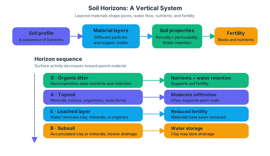
A soil horizon is a recognizable horizontal layer with its own material and properties. The particle size and composition of each horizon can change porosity—the fraction of pore space—and permeability—how readily water moves through connected pores. Together with nutrient content and water retention, these properties influence soil fertility.
A simplified soil profile can be read as a sequence from biologically active surface material toward partially weathered parent material:
| Horizon | Typical composition and role | Likely environmental effect |
|---|---|---|
| $O$ | Organic litter and decomposing material | Adds nutrients and improves water retention |
| $A$ | Mineral particles mixed with humus and organisms | Often supports roots; moderate fertility and infiltration |
| $E$ | A leached layer where water removes some clay, minerals, or organic matter | May have reduced fertility |
| $B$ | Material accumulated from upper layers, often including clay or minerals | Can hold water but may slow drainage |
| $C$ | Partially weathered parent material | Fewer organisms and less developed soil structure |
| $R$ | Consolidated bedrock | Very low porosity and permeability unless fractured |
These horizons do not behave identically. A clay-rich $B$ horizon may contain many very small pores and therefore retain water, but those pores may connect poorly, slowing infiltration. An organic-rich $O$ or $A$ horizon can increase fertility by storing nutrients and supporting decomposers.
Texture, water holding capacity, and fertility
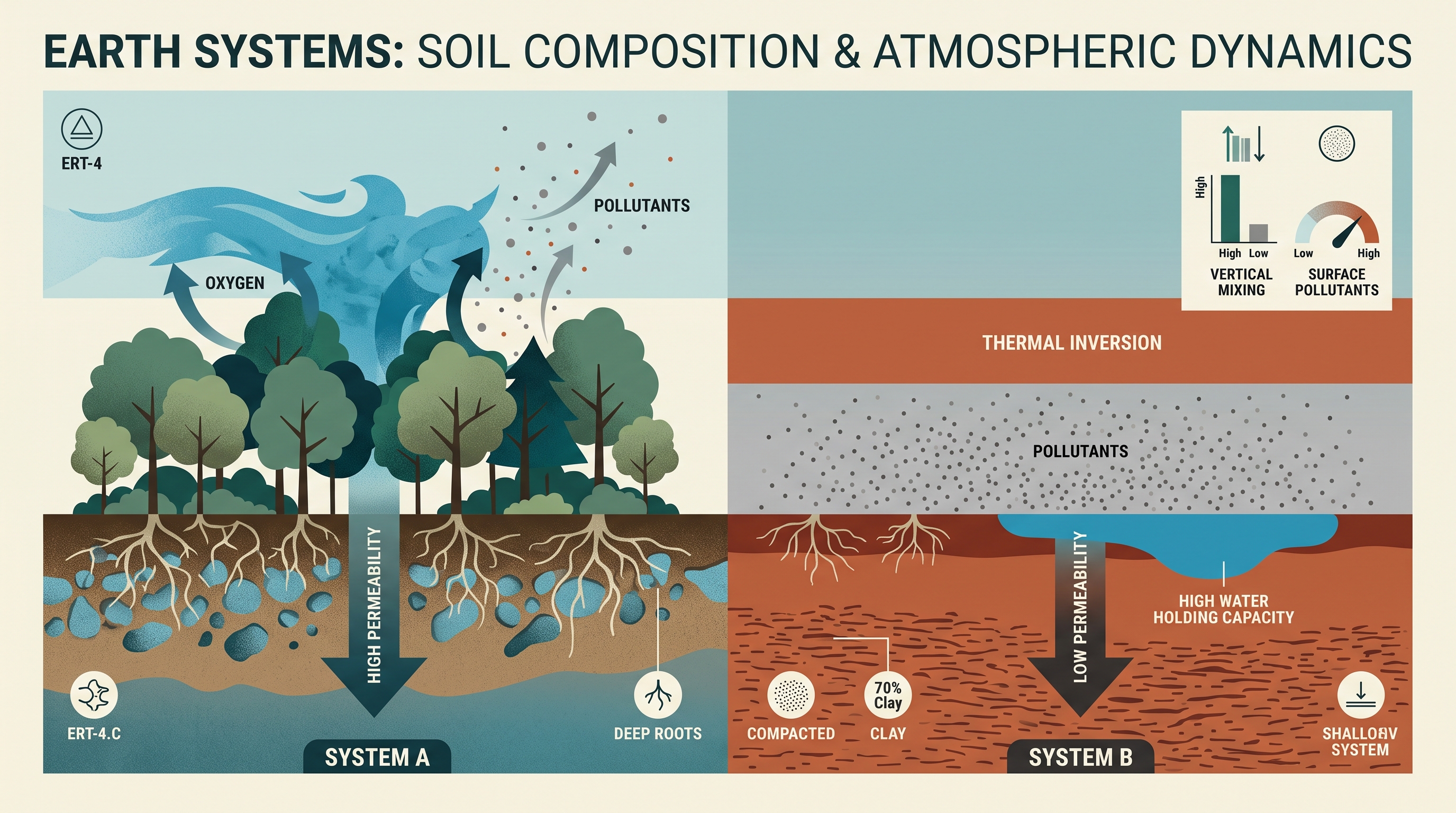
Soil texture describes the relative percentages of sand, silt, and clay. Sand has the largest particles and usually creates larger pores, so water moves through it rapidly. Clay has the smallest particles, creating extensive surface area and high water retention, but often slower permeability. Silt has intermediate particle size and behavior.
A soil texture triangle classifies soil from its percentages of clay, silt, and sand. The three percentages must total $100%$. Loam is a blend of all three particle sizes that commonly balances drainage, water holding capacity, aeration, and nutrient retention; that balance allows it to support a variety of crops.
ERT-4.C.1: Water holding capacity—the total amount of water soil can hold—varies with different soil types. Water retention contributes to land productivity and fertility of soils.
Worked example: Suppose a field soil contains $40%$ sand, $40%$ silt, and $20%$ clay. The percentages sum to $100%$, so the sample can be located on a texture triangle. Compared with a nearly pure sand, it should retain more water; compared with a soil containing much more clay, it should generally allow faster drainage. Its suitability for crops depends not only on texture but also on organic matter, nutrients, and compaction.
Misconception check: High water-holding capacity does not automatically mean high fertility. A soil may retain water yet lack usable nutrients, oxygen, or suitable drainage.
Testing soil properties
Soil testing supports decisions such as irrigation and fertilizer requirements. Chemical methods measure properties such as nutrient availability or acidity; physical methods examine texture, water retention, compaction, infiltration, or drainage; biological methods examine living organisms or biological activity in the soil.
For an investigation, identify the research method, design, measurements, and variables before collecting data. For example, place equal soil masses in containers with either bare soil or vegetation covering. Add the same volume of water to each container and measure runoff amount and appearance. The independent variable is the covering treatment; runoff volume or turbidity is a dependent measurement.
If vegetation reduces runoff, the mechanism is increased interception by leaves and greater infiltration through roots and soil pores. A controlled comparison must keep soil type, container size, water volume, and slope consistent so that vegetation—not an uncontrolled difference—explains the result.
Earth’s atmospheric layers
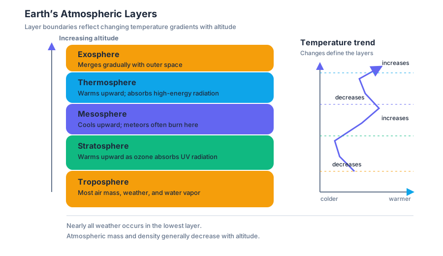
Earth’s atmosphere is divided into the troposphere, stratosphere, mesosphere, thermosphere, and exosphere. These layers are identified primarily by changes in the temperature gradient with altitude, not simply by their distance from Earth’s surface.
The troposphere is the lowest layer and contains most atmospheric mass and nearly all weather. Temperature generally decreases with altitude. Above it, the stratosphere has a temperature pattern that generally increases with altitude because ozone absorbs ultraviolet radiation. The mesosphere again generally cools upward, while the thermosphere warms upward as sparse gases absorb high-energy radiation. The exosphere gradually merges with outer space.
Thermal inversions and system balance
A thermal inversion occurs when the normal atmospheric temperature gradient is altered or reversed, so relatively warm air lies above cooler air near the surface. The cooler, denser air cannot rise easily through the warmer layer, reducing vertical mixing and allowing pollutants to accumulate near the ground.
This illustrates ERT-4, the enduring understanding that Earth’s systems interact and can result in a state of balance over time: soil, vegetation, water, and air exchange matter and energy. A change in vegetation can alter infiltration and runoff; atmospheric stability can then influence how pollutants remain concentrated or disperse.
Skill connection — Scientific Experiments: The soil investigation applies ERT-4.C: describe similarities and differences between properties of different soil types. It also uses ERT-4.C.1, ERT-4.C.2, ERT-4.C.3, and ERT-4.C.4 by linking water holding capacity, horizon composition, testing methods, and texture classification to measurable outcomes.
Retrieval check: A soil sample is $70%$ sand, $20%$ silt, and $10%$ clay. Predict whether its permeability and water holding capacity are closer to those of a sandy soil or a clay-rich soil, and justify both predictions using particle size and pore structure. Then explain why a thermal inversion can increase surface-level air pollution without adding any new pollutant.
Source Materials
- AP Environmental Science Course and Exam Description
- Review the Clarifications (.pdf)
- AP Environmental Science Course Overview
- AP Environmental Science Course at a Glance
- AP Environmental Science Course at a Glance Poster
- AP Environmental Science
- AP Environmental Science
- AP Environmental Science Sample Syllabus 1