From the free course AP Environmental Science on Lykke
4.1 Plate Tectonics · 4.2 Soil Formation and Erosion
Key concepts: Plate tectonics · Global distribution of plate boundaries · Convergent, divergent, and transform plate boundaries · Using figures and maps to identify plate boundaries · Environmental issues related to plate boundaries · Soil formation during primary succession · Soil erosion · Effects of forested versus clear-cut areas · Land-use change and grazing · Cultural ecosystem services provided by mature forests
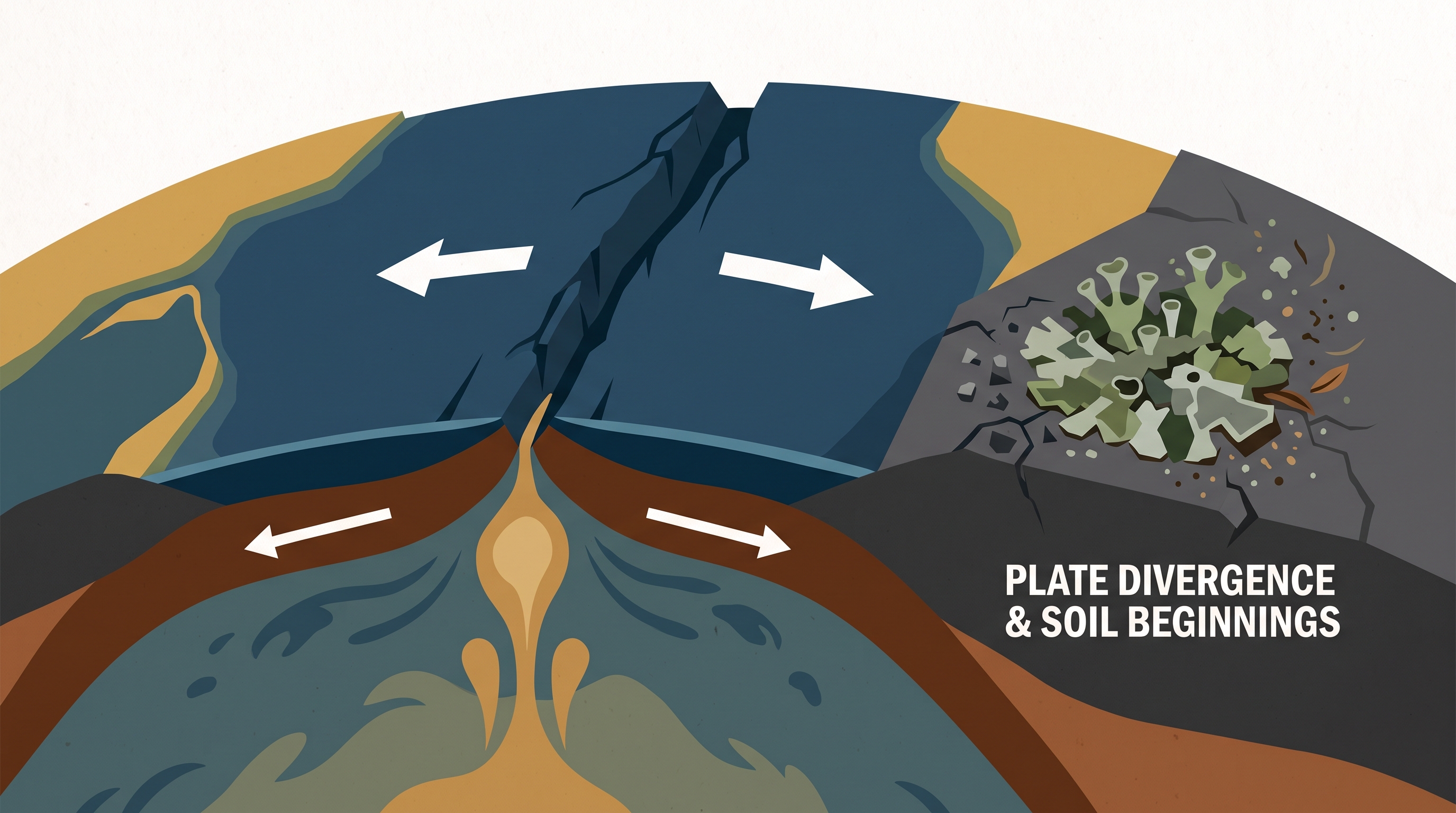
Plate tectonics describes the movement of rigid pieces of Earth’s lithosphere over the softer asthenosphere beneath them. That slow motion reshapes landscapes, creates hazards, and can even influence where ecosystems develop: the Serengeti National Park, for example, lies above a divergent plate boundary, where…
4.1 Plate Tectonics · 4.2 Soil Formation and Erosion
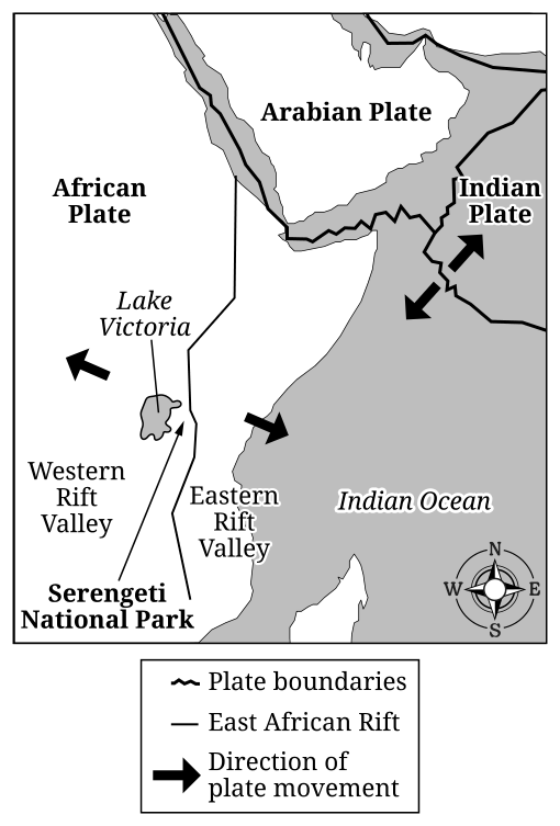
Plate tectonics describes the movement of rigid pieces of Earth’s lithosphere over the softer asthenosphere beneath them. That slow motion reshapes landscapes, creates hazards, and can even influence where ecosystems develop: the Serengeti National Park, for example, lies above a divergent plate boundary, where plates move apart.
Plate boundaries: three motions, three landscape patterns
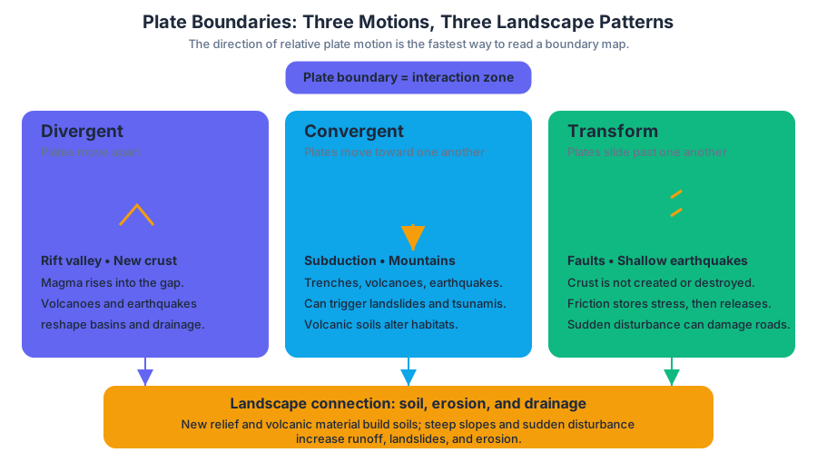
A plate boundary is the zone where two tectonic plates interact. The direction of motion determines the boundary type and provides the fastest way to interpret a map or diagram.
| Boundary type | Relative plate motion | Common geological result | Environmental connection |
|---|---|---|---|
| Divergent | Plates move apart | Rift valleys, new crust, volcanic activity, earthquakes | Creates basins, elevated terrain, and changing drainage patterns |
| Convergent | Plates move toward one another | Subduction zones, trenches, volcanoes, mountains, powerful earthquakes | Produces volcanic soils, landslides, tsunamis, and altered habitats |
| Transform | Plates slide horizontally past one another | Frequent shallow earthquakes along faults | Causes sudden landscape disturbance and damage to infrastructure |
At a divergent boundary, rising magma fills the gap as crust separates. On continents, this process can form a rift valley; beneath oceans, it produces new seafloor. At a convergent boundary, one oceanic plate may be forced beneath another plate in subduction, or two continental plates may collide and build mountains. At a transform boundary, crust is neither created nor destroyed overall, but friction can cause earthquakes when plates suddenly slip.
Reading a plate-boundary map
Use the arrows, not the landscape name, as the primary evidence. Arrows pointing away from a line indicate a divergent boundary; arrows pointing toward one another indicate convergence; arrows moving parallel to the line in opposite directions indicate a transform boundary.
Worked interpretation — Serengeti National Park: A figure shows a long continental rift through East Africa. If the arrows on opposite sides point away from the rift, the boundary is divergent. The correct conclusion is not merely “there are volcanoes,” because volcanoes can occur at more than one boundary type; the decisive evidence is that the plates are separating.
Misconception check — “Every earthquake marks a convergent boundary.” Earthquakes occur at all three boundary types. Transform boundaries commonly produce shallow earthquakes from sideways fault motion, while convergent boundaries can produce earthquakes associated with subduction and collisions.
From tectonic motion to environmental problems
The AP skill ERT-4.A.5 asks you to explain how environmental events represented visually relate to broader environmental issues. A diagram of a rift is therefore not just a geology question: it can be connected to volcanic hazards, earthquake risk, habitat disruption, soil development, groundwater movement, and human settlement.
For example, a volcanic event may destroy existing vegetation but later add mineral-rich parent material. An earthquake may alter stream channels or trigger landslides, while a tsunami generated near a convergent boundary can transport sediment and pollutants far inland. The environmental effect depends on both the tectonic event and the vulnerability of the surrounding ecosystem or human community.
Soil begins with parent material
ERT-4.B.1: Soils are formed when parent material is weathered, transported, and deposited. Parent material may be bedrock, volcanic material, glacial sediment, or sediment moved by water, wind, or gravity.
Key idea: Soil is not simply “dirt.” It is a developing layer produced by the interaction of mineral material, organisms, water, air, and time.
Physical weathering breaks rock into smaller pieces without changing its chemical identity. Chemical weathering changes minerals through reactions with water, acids, or oxygen. Once material is loosened, erosion transports it; deposition places it somewhere new, where organisms and decomposing matter can help build soil.
Soil formation during primary succession
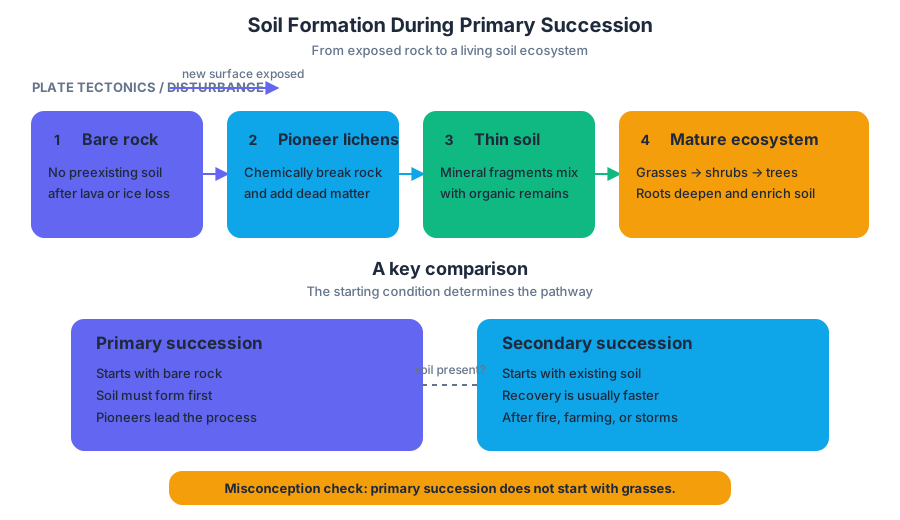
Primary succession begins on a surface without preexisting soil, such as newly exposed rock. Pioneer species—often lichens and certain microorganisms—colonize the surface. Lichens chemically and physically break down rock; when they die, their organic remains mix with mineral fragments, creating the first thin layer of soil.
As soil depth and water-holding capacity increase, grasses and small plants can establish. Their roots further weather the substrate, and their dead material adds organic matter. Later, shrubs and trees may form a mature forest, although the final community depends on climate, disturbance, and available species.
Misconception check — “Primary succession starts with grasses.” It starts before grasses can grow. Without soil, pioneer organisms must first contribute to weathering and organic-matter accumulation.
Vegetation, erosion, and experimental evidence
Vegetation is an environmental protection system. Roots hold soil particles in place, stems slow surface runoff, and leaf litter cushions raindrop impacts. Maintaining vegetation therefore reduces soil erosion, preserves soil fertility, decreases sediment entering streams, and helps maintain clearer aquatic habitat.
A sound experiment comparing a forested area with a clear-cut area could use land-cover treatment as the independent variable and measure a dependent variable such as mass of eroded sediment, runoff volume, or stream turbidity. Replicated plots with similar slope, soil, rainfall exposure, and area would improve validity; untreated or forested plots could serve as a control condition.
Worked design: Place identical sediment traps below several forested plots and several clear-cut plots. After the same storm, dry and weigh the collected sediment. If clear-cut plots produce more sediment, the evidence supports the hypothesis that removing vegetation increases erosion. A strong response identifies the variables and explains the mechanism—not merely that “clear-cutting is harmful.”
Interpreting land-use change and ecosystem services
When a graph shows land-use changes and grazing from $1700$ to $1950$, first identify the direction and timing of each trend. An increase in grazing or conversion of forest to pasture indicates greater vegetation removal and greater potential for soil exposure; if erosion rises afterward, the pattern supports—but by itself does not prove—a causal relationship.
A mature forest can provide a cultural ecosystem service, such as recreation, spiritual value, aesthetic enjoyment, education, or cultural identity. This differs from regulating services such as erosion control and water purification: cultural services are nonmaterial benefits people receive from ecosystems.
Retrieval check
A map shows plates moving away from a central continental valley, followed by a photograph of bare rock colonized by lichens. Identify the boundary type and explain the first step in soil formation. Answer: The boundary is divergent because the plates separate. Lichens weather the rock and add organic matter when they die, beginning soil formation during primary succession.
Source Materials
- AP Environmental Science Course and Exam Description
- Review the Clarifications (.pdf)
- AP Environmental Science Course Overview
- AP Environmental Science Course at a Glance
- AP Environmental Science Course at a Glance Poster
- AP Environmental Science
- AP Environmental Science
- AP Environmental Science Sample Syllabus 1
- Figure 1. Tectonic Plate Movement near East Coast of Africa
- AP/College Environmental Science-Khan Academy
- AP Environmental Science Exam-College Board
- AP Environmental Science Units-Save my Exams