From the free course AP World History: Modern on Lykke
4.1 Technological Innovations from 1450 to 1750 · 4.2 Exploration: Causes and Events from 1450 to 1750
Key concepts: Technological innovations from 1450 to 1750 · Exploration causes and events from 1450 to 1750 · Maritime technology and navigational skills · China’s naval expeditions in the Indian Ocean basin · Western European geographical knowledge and mapmaking · Technological change and human development · Intended and unintended consequences of technological advances · Causation in historical analysis · Transoceanic interconnections · The TEC theme: technology and innovation
Explain and apply 4.1 Technological Innovations from 1450 to 1750 · 4.2 Exploration: Causes and Events from 1450 to 1750.
4.1 Technological Innovations from 1450 to 1750 · 4.2 Exploration: Causes and Events from 1450 to 1750
A ship could cross an ocean only when technology, accumulated knowledge, political support, and economic motives worked together. Between approximately $1450$ and $1750$, innovations in sailing and navigation made transoceanic travel more reliable—but also produced consequences that explorers and rulers could not fully control.
TEC — Technology and Innovation: Human adaptation and innovation increased efficiency, comfort, and security while reshaping development and interaction through both intended and unintended consequences.
4.1 Technological Innovations from 1450 to 1750
Unit 4: Learning Objective A: Explain how cross-cultural interactions resulted in the diffusion of technology and facilitated changes in patterns of trade and travel from $1450$ to $1750$.
KC-4.1.II: Knowledge, scientific learning, and technology from the Classical, Islamic, and Asian worlds spread, facilitating European technological developments and innovation.
KC-4.1.II.A: New tools, ship designs, and improved understanding of wind and current patterns enabled transoceanic travel and trade.
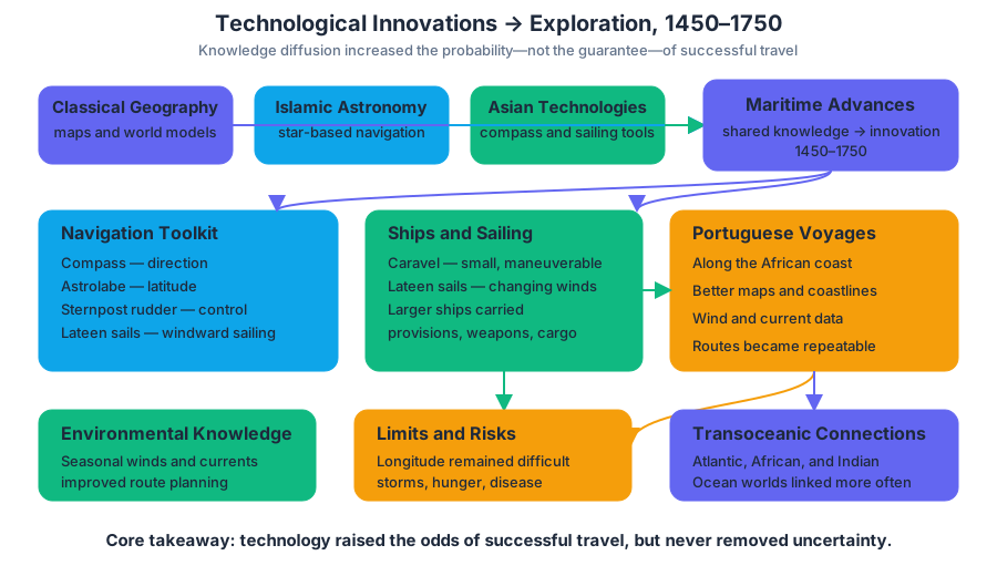
Maritime technology was not a single European invention. Sailors and scholars combined older Classical geographical ideas, Islamic astronomical and navigational learning, and Asian technologies such as the magnetic compass, sternpost rudder, and advanced sail designs. The caravel, a relatively small and maneuverable ship using lateen sails, could move more effectively against changing winds; larger ships could carry provisions, weapons, and cargo across longer routes.
Navigational skill also mattered. Mariners used the compass to determine direction, the astrolabe to estimate latitude from the height of a star, and practical observations of seasonal winds and ocean currents. These tools did not eliminate danger: longitude remained difficult to calculate, storms could destroy ships, and crews still faced hunger and disease. Technology increased the probability of successful travel rather than guaranteeing it.
Worked example — tracing diffusion:
- Asian compass technology improved a navigator’s ability to maintain direction.
- Islamic scholars preserved and developed astronomical knowledge useful for navigation.
- European mariners adapted these resources to Atlantic conditions and combined them with ship designs suited to long voyages.
- Portuguese voyages along the African coast generated additional information about winds, currents, and coastlines.
- The result was a new pattern of travel: European ships could connect the Atlantic, African, and Indian Ocean worlds more consistently.
The intended benefits were practical and political: ships could carry more cargo, rulers could reach distant markets, and sailors could travel with greater efficiency and security. An unintended consequence was that the same improvements in navigation and ship design made armed encounters across oceans more feasible. A tool developed to locate a route or manage a voyage could also increase the ability of states and merchants to impose unequal relationships on peoples they encountered.
Ming China and the Indian Ocean
China demonstrated that long-distance maritime exploration did not begin with western Europe. From $1405$ to $1433$, the Ming admiral Zheng He led seven major expeditions under the Yongle emperor and his successors. The fleets sailed from China through Southeast Asia and across the Indian Ocean to ports in India, Arabia, and the East African coast.
The voyages pursued several connected purposes: displaying Ming power, strengthening diplomatic and tribute relationships, facilitating trade, searching for prestige and information, and extending the emperor’s awareness of the wider world. The enormous fleets carried luxury goods and diplomatic representatives, and foreign rulers sometimes sent envoys or tribute to the Ming court.
These expeditions generated geographic and political knowledge about ports, coastlines, rulers, commercial networks, and monsoon routes. They show that the Indian Ocean was already an interconnected basin before European vessels entered it. However, the voyages did not produce a permanent Chinese overseas empire. After the expeditions ended, court officials criticized their expense, while the Ming government faced other priorities, including threats along its northern frontier and the cost of maintaining the fleet. The state therefore redirected resources away from large-scale naval expeditions.
Misconception check — “Europe discovered oceanic navigation.”
European mariners developed important combinations of ships, instruments, and sailing knowledge, but they did not invent global navigation from nothing. Chinese, Indian, Arab, Persian, and other sailors had long traveled the Indian Ocean. The historically stronger explanation is cross-cultural accumulation: European exploration depended partly on knowledge created or transmitted by other societies.
Mapmaking and the Expansion of Geographical Knowledge
Western European geographical knowledge was uneven. Commercial isolation from much of Asia and Africa meant that European mapmakers often relied on inherited Classical sources, including the work associated with Ptolemy, as well as information transmitted through Islamic scholars and merchants. These maps could contain serious distortions, especially for regions European travelers had not personally visited.
Exploration changed mapmaking in a feedback loop:
older Classical, Islamic, and Asian knowledge
                 ↓
initial European maps and route assumptions
                 ↓
voyage reports, coastal observations, and latitude readings
                 ↓
revised charts and more accurate coastlines
                 ↓
better planning for later voyages
European mapmakers incorporated new voyage reports into portolan-style charts, which emphasized coastlines, harbors, and sailing directions. As Portuguese sailors explored the African coast and rounded the Cape of Good Hope, maps increasingly represented actual coastal observations rather than only inherited speculation. Improved maps therefore both resulted from exploration and enabled further exploration by helping captains plan routes, identify ports, and compare distances.
Source-interpretation example: If one map shows a more recognizable West African coastline and a fuller southern half of the world than an earlier map, the strongest explanation is not simply “Europe became more curious.” The change may reflect Portuguese maritime technology and navigational skills, information from Chinese naval expeditions in the Indian Ocean basin, or the earlier limits of western European geographical knowledge. A historian must match each answer to the map’s visible evidence and historical context.
4.2 Exploration: Causes and Events from 1450 to 1750
Unit 4: Learning Objective B: Explain how the expansion of maritime exploration was related to economic, political, and cultural developments from $1450$ to $1750$.
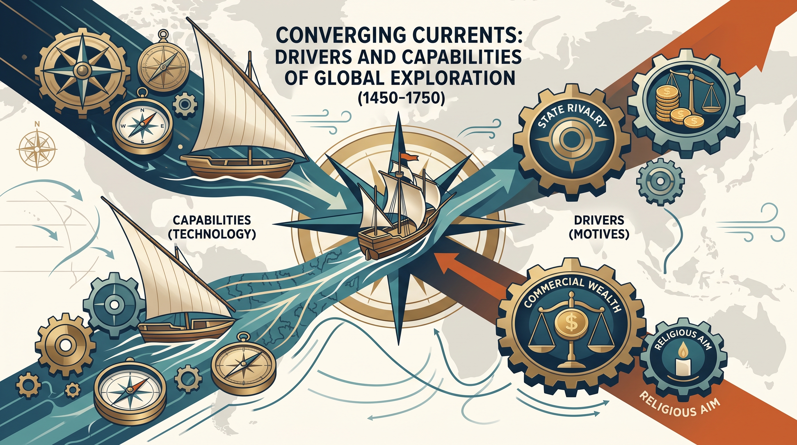
European exploration had multiple causes. Monarchies sought new sources of wealth and greater political power; merchants wanted direct access to Asian luxury goods; and Christian rulers and missionaries pursued religious expansion. Competition among states encouraged rulers to sponsor voyages that might claim routes, gather information, and strengthen national prestige.
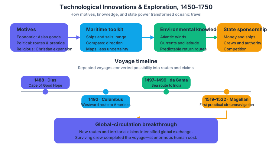
Portugal illustrates historical causation clearly. Its Atlantic position, experience with coastal sailing, royal sponsorship, commercial ambitions, and developing maritime technology encouraged voyages down the western coast of Africa. Portuguese navigators gradually learned to use Atlantic wind systems and currents, making longer voyages possible. In $1488$, Bartolomeu Dias rounded the Cape of Good Hope; in $1497$–$1499$, Vasco da Gama reached India by sea.
Spain pursued a different route to the same broad goals. Christopher Columbus’s voyage in $1492$ sought westward access to Asian markets but instead connected Europeans with the Americas. Later, Ferdinand Magellan’s expedition, begun in $1519$ and completed by surviving crew members in $1522$, demonstrated the practical possibility of circumnavigating the globe, although at enormous human cost.
Causation chain — from innovation to exploration:
| Causal factor | How it enabled exploration |
|---|---|
| Improved ships and sails | Increased maneuverability and range |
| Compass and astronomical tools | Supported direction-finding and latitude estimates |
| Knowledge of winds and currents | Made routes more predictable |
| Mapmaking and voyage reports | Reduced uncertainty for later sailors |
| State sponsorship | Supplied money, ships, crews, and authority |
| Economic and political motives | Made risky voyages seem worthwhile |
Skill focus — Historical Reasoning Process: Causation; 4.A Identify and describe a historical context for a specific historical development or process. To contextualize exploration, place it within the growth of powerful states, expanding commercial networks, technological diffusion, and competition for access to wealth. Do not treat a voyage as an isolated heroic event; explain the conditions that made it possible.
Skill focus — 5.B Explain how a historical development or process relates to another historical development or process. A strong explanation connects maritime innovation to exploration rather than merely listing both. For example: improved knowledge of winds and currents made Portuguese voyages more reliable, while each voyage produced information that improved maps and navigation for subsequent travelers.
Misconception check — “Technology alone caused exploration.” Ships and instruments created possibilities, not motives. Without royal financing, commercial goals, religious aims, and interstate rivalry, many innovations would not have produced sustained transoceanic exploration.
Retrieval check: In two or three sentences, explain why the Ming voyages of $1405$–$1433$ and Portuguese voyages after the fifteenth century represent different outcomes of maritime capability. Include one purpose of the Ming expeditions, one factor behind Portuguese exploration, and one reason improved maps mattered.
Source Materials
- AP World History: Modern Course and Exam Description
- AP World History: Modern Course and Exam Description Clarifications and Corrections
- AP World History: Modern Course Overview
- AP World History: Modern Course at a Glance
- AP World History: Modern Course at a Glance Poster
- AP World History: Modern
- AP World History: Modern
- AP World History: Modern Sample Syllabus 1
- [a] Identify ONE development during the period 1450 to 1750 that contributed to the activities shown in the image.
- [a] Identify ONE development during the period 1450 to 1750 that contributed to the activities shown in the image.
- AP World History Past Exam Questions — AP Central
- Khan Academy — AP World History: Modern