From the free course World History Volume 1 on Lykke
15.3 The People of the Sahel
Key concepts: Sahel · Sahara and savanna environmental transition · Nomadic pastoralism and seasonal migration · Camel domestication and desert travel · Trans-Saharan long-distance trade · Gao and the early Songhai states · Trade routes and territorial expansion · Environmental adaptation · Sahelian geography · Arabic origins of the word Sahel
By the end of this section the student can: Discuss the development of the Gao and early Songhai states; Explain why the people of the Sahel were able to take advantage of long-distance trade routes; Explain why some nomadic African tribes settled at the edges of the Sahara
15.3 The People of the Sahel
The Sahara was not an empty wall separating North and West Africa. Routes, oases, herds, and camel caravans made movement across the desert possible, while the semiarid Sahel became a meeting zone where nomadic pastoralists, settled farmers, merchants, and states interacted. The central historical question is therefore not simply how people survived near the desert, but how environmental limits created opportunities for mobility, exchange, and political power.
African Geography, Migration, and Settlement
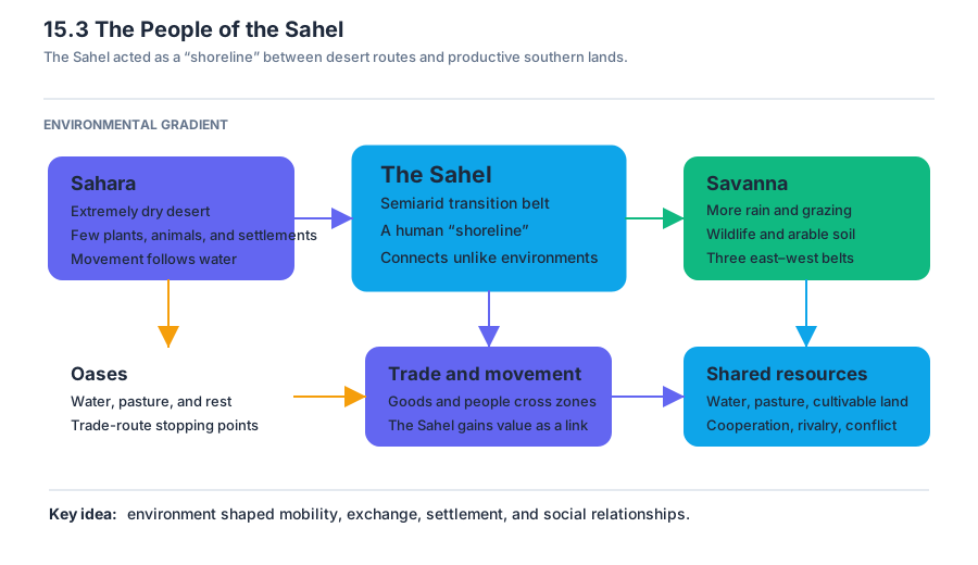
The Sahel is a semiarid belt south of the Sahara. It separates the desert to the north from the more productive savanna and tropical woodland to the south. Its name comes from the Arabic sahil, meaning “shore.” The term reflects an older image of the Sahara as a vast sea of sand, with the Sahel serving as its shoreline. This metaphor captures both the desert’s apparent immensity and the Sahel’s position as a zone where people and goods could move between very different environments.
Sahel: The semiarid environmental belt immediately south of the Sahara, forming a transition between the desert and the savanna and tropical woodland farther south.
The Sahara’s extremely dry conditions supported only small-scale settlements. Plants and animals were scarce, and communities clustered around oases, which occupied only a tiny fraction of the desert’s total landmass. An oasis could provide water, pasture, and a place to rest, making it a natural stopping point for travelers. During the Middle Ages, these locations became crucial hubs in trade routes crossing the Sahara.
South of the Sahel lay the savanna, a region of environmental transition rather than a single uniform landscape. The savanna consisted of three successive east–west belts, reflecting changing conditions across the region. Compared with the Sahara, it offered more rainfall, grazing land, wildlife, and arable soil. These differences mattered economically: the farther travelers and traders could connect the desert to the productive lands south of it, the more valuable the Sahel became as an intermediary zone.
Environmental conditions shaped settlement and economic practice throughout this entire zone. Rainfall was limited and uneven, and grazing resources changed with the seasons. Communities therefore had to organize their lives around access to water, pasture, and cultivable land. The Sahel’s societies were not simply divided into “desert nomads” and “settled farmers.” Their relationships included trade, cooperation, competition, and sometimes violent conflict over scarce resources.
Nomadic Pastoralism and Seasonal Migration
Nomadic pastoralism is a way of life based on herding animals while moving periodically in search of pasture and water. In the Sahara and Sahel, nomads migrated their flocks and herds to better grazing areas. Movement became especially important during the hottest and driest seasons, when existing pastures could no longer support animals. Herds might be taken toward the Maghreb in the north or toward the Sahel in the south.
This seasonal movement brought nomadic pastoralists into direct contact with settled agricultural communities. Such encounters could be economically useful because pastoralists and farmers occupied different ecological niches, but they could also produce conflict. Both groups competed for precious resources in a hostile environment, particularly grazing land and water. The location of settlements at the edges of the Sahara was therefore not accidental: these communities occupied areas where desert mobility and agricultural production met.
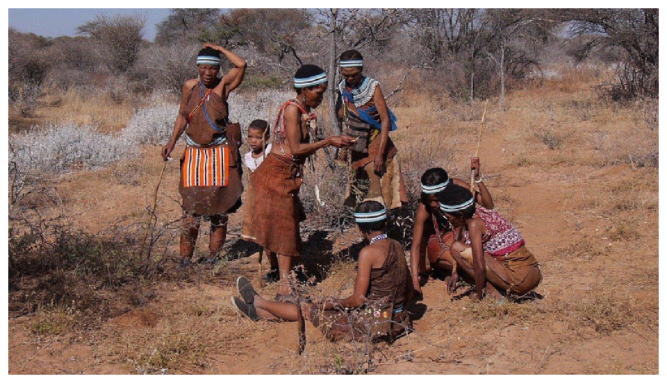
Pastoralists dominated much of the Sahara, but they were not the only people who lived there. Small groups such as the Haratin also called the oases home. The population of the desert thus included mobile herders, oasis residents, merchants, and agricultural communities along its margins. The Berbers, or Amazigh, played an especially important role in the history of the Maghreb and Sahel. They included nomads, settled agriculturalists, merchants, and traders living across areas that correspond to modern Morocco, Algeria, Mauritania, and Tunisia.
Camel Domestication and Desert Travel
The camel transformed the possibilities of desert travel. Its broad, padded feet allowed it to walk more easily across soft sand, while its ability to travel between widely separated water sources made longer journeys more practical. The camel did not make the Sahara safe or easy to cross; desert travel remained precarious and dangerous. It did, however, make movement more reliable and extended the distance that travelers could cover between oases.
This change had an important economic consequence. Before camel transport became central, trade routes were more localized and connected nearby trading centers. With camels, desert travelers could consider sending large-scale, regular trading caravans across the Sahara. The desert became a difficult transportation environment rather than an absolute barrier.
The camel’s historical importance lay not in eliminating desert risk, but in making long-distance travel sufficiently reliable for regular commercial exchange.
Desert transportation nevertheless remained largely in the hands of nomadic peoples who understood the terrain and its limited resources. The Sanhaja were especially important in the western Sahara, while the Tuareg played a major role farther east. Their knowledge of routes, oases, seasonal conditions, and desert travel gave them influence over the movement of people and goods. Control of transportation could therefore become a source of economic and political power.
Trans-Saharan Long-Distance Trade
Trans-Saharan trade developed gradually. It began with localized segments linking nearby trading centers and eventually expanded into systems controlled by larger states across vast territories. The crucial geographic fact was the Sahel’s position between two contrasting economic zones: the Sahara to the north and the more productive regions to the south. The peoples of the Sahel could benefit from long-distance exchange because they stood at the point where desert routes met agricultural and resource-rich regions.
Oases made this network possible by providing the intervals of water and settlement required for desert crossings. Traders could move goods from one oasis to another, while markets and settlements along the desert’s southern edge connected these routes to the savanna and tropical woodland. In this way, the Sahara linked rather than merely separated North and West Africa. The movement of goods across it depended on environmental knowledge, specialized transport, and political control of strategic locations.
The expansion of trade also changed the scale of political organization. A small trading center might first serve a local network. As trade increased, rulers could seek control over additional routes, markets, and surrounding territory. Some kingdoms were short-lived, but they still mattered because they connected local and regional African economies to a wider commercial network touching Europe, Asia, and Arabia. The history of Sahelian states therefore cannot be separated from the movement of goods and people across ecological boundaries.
The Gao Dynasty and Early Songhai
The development of Gao and the early Songhai states was closely linked to the expansion and exploitation of trans-Saharan trade. Gao emerged as a trade city and soon became the capital of the Songhai kingdom. Its location enabled contact between the desert trade routes and the societies of the Niger region. Political development followed economic opportunity: as the trade center became more important, rulers had stronger incentives to organize authority around it and to benefit from the commerce passing through it.
The communities that formed early Songhai identity included the Sorko, Gabibi, and Gow peoples. Before the emergence of Songhai political power, the Sorko dominated the river and raided the agricultural communities of the Gabibi, attacking granaries and plundering settlements. This conflict illustrates how control of food production and riverine resources could shape power in the region.
The regional dynamic changed in the ninth century with the arrival of a nomadic, horse-riding people who spoke Songhai, a language in the Nilo-Saharan language family. Over time, the Sorko, Gabibi, and Gow adopted the language of their conquerors. Their cultures collectively formed the basis of Songhai identity and the Songhai state, whose capital was at Kukiya. Songhai identity thus developed through conquest, cultural interaction, and the incorporation of different communities rather than through a single, isolated population.
As the Songhai state took shape, its people maintained steady contact with Muslim traders at Gao. This connection tied the emerging state to the commercial world of the Sahara and North Africa. Gao’s importance rested not only on local agriculture or political authority, but also on its position within a long-distance trading system. In the sixteenth century, Songhai grew into a larger and wealthier state than even the celebrated Mali, demonstrating the lasting political value of controlling major trade centers.
The key implication is that control of a strategic trade location such as Gao could help early Songhai rulers turn commercial access into territorial expansion. By holding the city where desert traders met the Niger region, they gained a position from which to influence markets, regulate movement, and extend authority beyond the immediate settlement. Gao was therefore not merely a capital; it was the geographic instrument through which Songhai connected local power to the wider trans-Saharan economy.
Content adapted from OpenStax World History, Volume 1: to 1500 by Ann Kordas et al., licensed CC BY 4.0.
Source Materials
Study World History Volume 1 on Lykke
This course page is free to open: signed out, you can read its first two sections, and signing in, on any plan, opens the rest. The free Lykke Chrome extension syncs your own Canvas courses, so ChatGPT, Claude and Muse can answer from your classes and deadlines. It only reads Canvas.
Add the free extensionSign in to open every sectionAll sections of World History Volume 1 · Browse more course pages