From the free course Geology on Lykke
Geology of the Oceans and Shorelines
Key concepts: Continental Margins · Abyssal Plains · Coastal Erosion · Tides and Waves · Sea Level Change
Explores the features of the ocean floor and the dynamic processes occurring at the interface of land and sea.
Geology of the Oceans and Shorelines
The Earth is fundamentally a marine planet, with approximately 71% of its surface submerged beneath the global ocean. From a geological perspective, the ocean floor is not merely a flooded version of the continents but a distinct tectonic and petrological regime characterized by thinner, denser basaltic crust. The study of the Geology of the Oceans and Shorelines encompasses the structural evolution of ocean basins, the sedimentological dynamics of the deep sea, and the high-energy interface where terrestrial and marine processes collide.
Understanding this domain requires a synthesis of plate tectonics, fluid dynamics, and historical geology. As sea levels fluctuate due to climatic and tectonic drivers, the boundary between land and sea—the shoreline—becomes one of the most geologically volatile environments on Earth.
Continental Margins: The Transition Zones
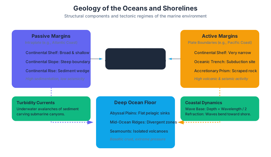
The Continental Margin is the submerged outer edge of a continent, representing the transition zone between thick, buoyant continental crust (primarily granitic) and thin, dense oceanic crust (primarily basaltic). These margins are categorized based on their proximity to active plate boundaries.
Passive vs. Active Margins
The distinction between passive and active margins is fundamental to understanding coastal morphology and seismic risk.
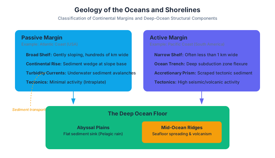
- Passive Margins: Located far from active plate boundaries (e.g., the Atlantic coast of North America). They are characterized by wide continental shelves, thick accumulations of sedimentary "clastic wedges," and low tectonic activity.
- Active Margins: Located at or near plate boundaries, typically subduction zones (e.g., the Pacific coast of South America). They feature narrow shelves, steep slopes, and deep-ocean trenches.
| Feature | Passive Margin | Active Margin |
|---|---|---|
| Tectonic Activity | Minimal (Intraplate) | High (Subduction/Transform) |
| Shelf Width | Broad (up to hundreds of km) | Narrow (often < 1 km) |
| Trench Presence | Absent | Common (Deep-ocean trenches) |
| Sedimentation | High (Deltaic and Pelagic) | Variable (often scraped into accretionary prisms) |
| Example | East Coast, USA | West Coast, South America |
Structural Components of the Margin
- Continental Shelf: A gently sloping, submerged surface extending from the shoreline toward the deep-ocean basin. It is geologically part of the continent.
- Continental Slope: A relatively steep structure that marks the boundary between continental and oceanic crust.
- Continental Rise: Found only at passive margins, this is a wedge of sediment deposited at the base of the slope by turbidity currents.
- Submarine Canyons: Deep, V-shaped valleys carved into the slope and shelf, often by ancient rivers during periods of lower sea level or by modern underwater landslides.
Definition: Turbidity Currents Dense, sediment-laden flows of water that move down the continental slope under the influence of gravity. These currents act as underwater "avalanches," transporting massive volumes of terrestrial sediment to the deep ocean floor, forming submarine fans.
The Deep Ocean Floor: Abyssal Plains and Ridges
Beyond the continental rise lies the deep-ocean basin, a realm of extreme pressure, low temperature, and unique geological features.
Abyssal Plains
The Abyssal Plains are arguably the flattest places on Earth. These vast, level areas of the deep-ocean floor result from the slow accumulation of fine-grained sediments (pelagic rain) that blanket the rugged underlying basaltic crust.
- Composition: Primarily biogenous ooze (shells of microscopic organisms) and terrigenous clay (fine dust blown from land or carried by currents).
- Significance: They serve as the ultimate "sink" for Earth's surface materials and provide a record of long-term climatic shifts.
Mid-Ocean Ridges (MORs)
The MOR system is a continuous underwater mountain range, extending over 65,000 km. It is the site of seafloor spreading, where new oceanic lithosphere is created.
Deep-Ocean Trenches
Trenches are the deepest parts of the ocean, formed at convergent plate boundaries where one lithospheric plate is subducted beneath another. The Mariana Trench, reaching depths of approximately 11,000 meters, is the most prominent example.
| Ocean Feature | Typical Depth (m) | Geological Origin |
|---|---|---|
| Continental Shelf | 0 – 200 | Submerged continental crust |
| Abyssal Plain | 3,000 – 6,000 | Sediment-covered oceanic crust |
| Mid-Ocean Ridge | 2,000 – 3,000 | Divergent boundary volcanism |
| Ocean Trench | 7,000 – 11,000 | Subduction zone flexure |
Coastal Dynamics: Tides and Waves
The shoreline is shaped by the continuous application of energy from the ocean, primarily in the form of waves and tides.
The Physics of Waves
Most ocean waves are generated by wind. The energy of a wave moves forward, but the water molecules themselves move in a circular orbital motion.
- Wave Base: The depth below which there is no wave-induced water movement. It is equal to approximately half the wavelength ($L/2$).
- Wave Refraction: The bending of waves as they approach the shore at an angle. Because waves slow down in shallower water, the part of the wave in deeper water "catches up," causing the wave front to become nearly parallel to the shoreline.
Tides: The Gravitational Pulse
Tides are periodic rises and falls in sea level caused by the gravitational pull of the Moon and Sun.
- Spring Tides: Occur when the Sun and Moon are aligned (New/Full Moon), resulting in the highest tidal range.
- Neap Tides: Occur when the Sun and Moon are at right angles (First/Third Quarter Moon), resulting in the lowest tidal range.
Coastal Erosion and Landforms
The interaction between wave energy and the shoreline produces distinct erosional and depositional features.
Erosional Landforms
Common on active margins or rocky coastlines where wave energy is concentrated on headlands through refraction.
- Wave-cut Cliffs: Formed by the cutting action of waves at the base of a cliff.
- Sea Arches and Stacks: Formed when headlands are eroded through, leaving isolated pillars of rock.
Depositional Landforms
Common on passive margins where sediment supply exceeds the rate of removal.
- Spits: Elongated ridges of sand that project from the land into the mouth of an adjacent bay.
- Barrier Islands: Low ridges of sand that parallel the coast at distances from 3 to 30 km offshore.
- Longshore Drift: The movement of sediment along the beach in a zigzag pattern caused by waves hitting the shore at an oblique angle.
\text{Longshore Transport Rate (Q)} \approx K \cdot P_l
\\
\text{where } P_l = \text{Longshore component of wave power}
\\
K = \text{Dimensionless coefficient related to sediment characteristics}
| Landform | Type | Description |
|---|---|---|
| Sea Stack | Erosional | Isolated rock pillar left after a sea arch collapses. |
| Tombolo | Depositional | A ridge of sand connecting an island to the mainland. |
| Estuary | Mixed | Drowned river valley where freshwater meets saltwater. |
| Marine Terrace | Erosional | A wave-cut platform uplifted above sea level by tectonics. |
Sea Level Change: Eustasy and Isostasy
Sea level is not constant; it is a dynamic baseline that responds to global and regional factors.
1. Eustatic Sea Level Change
Global changes in sea level related to the total volume of water in the ocean or the shape of the ocean basins.
- Glacial-Interglacial Cycles: During ice ages, water is trapped on land as ice, lowering sea levels by up to 120 meters.
- Tectonic Volume Changes: Rapid seafloor spreading creates "fat" mid-ocean ridges that displace water upward, raising sea levels.
2. Relative Sea Level Change
Local changes caused by the movement of the land itself.
- Isostatic Rebound: Land that was once depressed by the weight of glaciers rises after the ice melts (e.g., Scandinavia, Hudson Bay).
- Subsidence: Land sinking due to sediment loading or groundwater extraction (e.g., New Orleans, Venice).
Key Insight: Transgression vs. Regression A Transgression occurs when sea level rises relative to the land, moving the shoreline inland. A Regression occurs when sea level falls, exposing the former seafloor. These events are recorded in the rock record as specific vertical sequences of sedimentary facies.
Human Interaction and Coastal Engineering
As humans inhabit coastal zones, we attempt to stabilize dynamic shorelines using engineering structures. However, these often have unintended geological consequences.
Stabilization Structures
- Jetties: Built in pairs at the entrances to harbors to prevent sedimentation.
- Groins: Short walls built perpendicular to the shore to trap sand moving via longshore drift.
- Seawalls: Massive barriers built parallel to the shore to protect property from breaking waves.
- Breakwaters: Offshore barriers built parallel to the coast to create quiet water zones.
The "Sand Deficit" Problem
Groins and jetties trap sand on the "up-drift" side but cause accelerated erosion on the "down-drift" side because the longshore current is "starved" of sediment.
Common Pitfalls in Marine Geology
- Misunderstanding Wave Motion: A common mistake is thinking water moves forward with a wave in the open ocean. In reality, only the energy moves forward; the water particles return to nearly the same spot.
- Passive Margin = No Change: While "passive" implies no plate boundary, these margins are still dynamic. They experience massive sediment loading, salt tectonics, and significant sea-level fluctuations.
- The "Static Shoreline" Fallacy: Many coastal developments are built on the assumption that the shoreline is a fixed line. Geologically, the shoreline is a migrating feature that responds to every storm and every millimeter of sea-level rise.
Summary of Key Concepts
- Continental Margins define the edge of the continental block; passive margins are stable and wide, while active margins are narrow and tectonically volatile.
- Abyssal Plains are the result of millions of years of fine-grained sedimentation covering the volcanic topography of the ocean floor.
- Waves and Tides are the primary drivers of coastal change, with wave refraction focusing energy on headlands and longshore drift moving sediment like a conveyor belt.
- Sea Level is a function of both global water volume (eustasy) and local land movement (isostasy).
- Human Engineering often disrupts the natural "sand budget" of a coastline, leading to unintended erosion in adjacent areas.
Source Materials
- Physical Geology (Earle)
- 18: Geology of the Oceans
- Physical Geology (Panchuk)
- Fundamentals of Geology (Schulte)
- An Introduction to Geology (Johnson, Affolter, Inkenbrandt, and Mosher)
- Geological Structures - A Practical Introduction (Waldron and Snyder)
- Geology (Lumen)
- Engaging Adults in Science and Energy
Study Geology on Lykke
This course page is free to open: signed out, you can read its first two sections, and signing in, on any plan, opens the rest. The free Lykke Chrome extension syncs your own Canvas courses, so ChatGPT, Claude and Muse can answer from your classes and deadlines. It only reads Canvas.
Add the free extensionSign in to open every section