From the free course Geology on Lykke
Mass Wasting and Glaciation
Key concepts: Slope Stability · Landslides · Glacial Erosion · Ice Ages · Permafrost
Examines the movement of material downslope due to gravity and the powerful erosive force of moving ice.
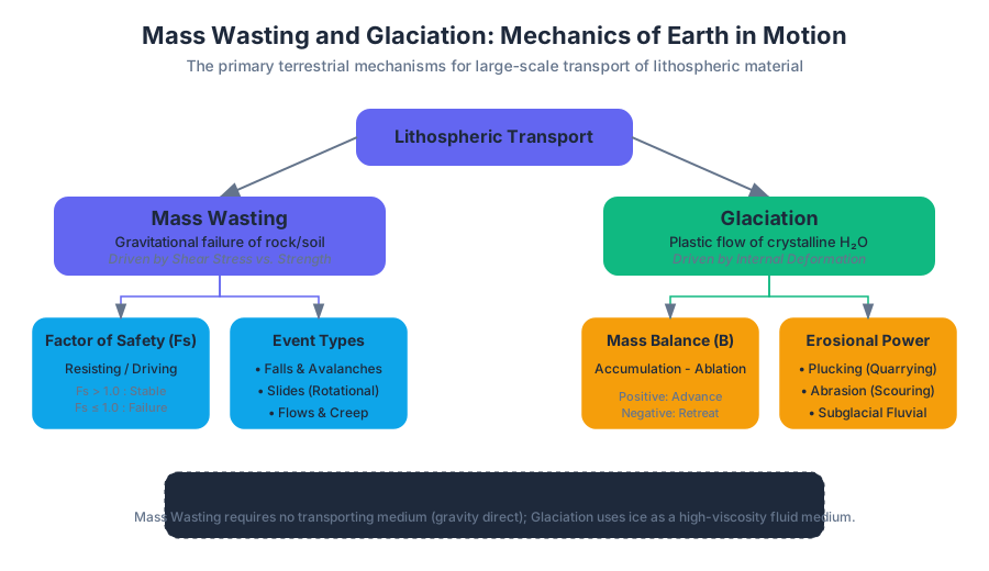
Mass Wasting and Glaciation: Mechanics of Earth in Motion
Mass wasting and glaciation represent the primary terrestrial mechanisms for the large-scale transport of lithospheric material. While driven by different physical states—one by the gravitational failure of unconsolidated or fractured rock, the other by the plastic flow of crystalline H₂O—both processes are governed by the fundamental interplay of shear stress and shear strength. In the context of a changing climate, understanding these systems is not merely a geomorphological exercise but a critical engineering necessity for hazard mitigation and resource management.
The Physics of Slope Stability
Mass wasting is the downslope movement of rock, regolith, and soil under the direct influence of gravity. Unlike erosion driven by water, wind, or ice, mass wasting does not require a transporting medium, though water often acts as a primary catalyst.
The Factor of Safety ($F_s$)
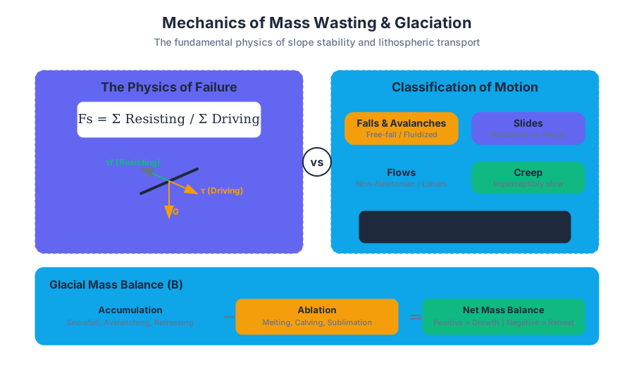
To evaluate the stability of any geological slope, engineers use the Factor of Safety, a dimensionless ratio of resisting forces to driving forces.
Definition: The Factor of Safety ($F_s$) is defined as $F_s = \frac{\sum \text{Resisting Forces}}{\sum \text{Driving Forces}}$.
- If $F_s > 1.0$, the slope is theoretically stable.
- If $F_s \leq 1.0$, the slope is in a state of failure or incipient failure.
The resisting force is primarily the shear strength ($\tau_f$) of the material, governed by the Mohr-Coulomb failure criterion: $$\tau_f = c + \sigma' \tan(\phi)$$ Where:
- $c$ is cohesion (interparticle bonding).
- $\sigma'$ is effective normal stress ($\sigma - u$, where $u$ is pore-water pressure).
- $\phi$ is the angle of internal friction.
Parameters Influencing Stability
The stability of a slope is a dynamic equilibrium influenced by several key variables:
| Parameter | Impact on Stability | Physical Mechanism |
|---|---|---|
| Slope Angle | Decreases stability | Increases the tangential component of gravity ($G_t$). |
| Water Content | Decreases stability | Increases pore pressure ($u$), reducing effective stress ($\sigma'$); adds weight. |
| Vegetation | Increases stability | Root systems provide "apparent cohesion"; evapotranspiration removes water. |
| Lithology | Variable | Bedding planes dipping parallel to the slope create daylighting structures prone to failure. |
| Seismicity | Decreases stability | Dynamic loading creates transient increases in shear stress and liquefaction potential. |
Mechanics of Mass Wasting Events
Mass wasting events are classified based on the type of material (rock vs. debris) and the type of motion (fall, slide, or flow).
Falls and Avalanches
Rockfalls occur when material detaches from a steep cliff along joints or bedding planes. Debris avalanches are higher-velocity events often triggered by volcanic eruptions or massive structural failures, characterized by air-cushioning or fluidization that allows for extreme run-out distances.
Slides: Rotational vs. Translational
- Slumps (Rotational Slides): Movement occurs along a concave-upward curved surface. These are common in thick accumulations of cohesive soils or weak sedimentary rocks. They often result in "stair-step" topography.
- Translational Slides: Movement occurs along a planar surface, such as a bedding plane, fault, or joint. These are often more dangerous because they can maintain structural integrity while accelerating to high speeds.
Flows and Creep
Debris flows (including lahars) behave as non-Newtonian fluids. They are mixtures of water, sediment, and air. Creep is the imperceptibly slow downslope movement of soil and regolith, driven by freeze-thaw cycles and wetting-drying cycles.
Worked Example: Infinite Slope Stability Analysis
In this low-level implementation, we calculate the Factor of Safety for a translational slide using the infinite slope model, accounting for the effect of the water table.
Glacial Systems and Dynamics
Glaciers are massive bodies of ice that form on land from the accumulation and recrystallization of snow. They are not static; they flow under their own weight, acting as the most powerful agents of erosion on Earth.
Glacial Mass Balance
The "health" of a glacier is determined by its mass balance ($B$), the difference between accumulation (snowfall, avalanching) and ablation (melting, calving, sublimation).
$$B = \int (a - s) dt$$
Where $a$ is the accumulation rate and $s$ is the ablation rate. The Equilibrium Line Altitude (ELA) marks the boundary where accumulation equals ablation.
The Mechanics of Ice Flow: Glen’s Flow Law
Ice behaves as a poly-crystalline material that deforms plastically. The relationship between the strain rate ($\dot{\epsilon}$) and shear stress ($\tau$) is non-linear.
\dot{\epsilon} = A \tau^n
Where:
- $A$ is a temperature-dependent fluidity parameter.
- $n$ is typically assumed to be 3 for glacial ice.
- $\tau$ is the basal shear stress, calculated as $\tau = \rho g h \sin(\alpha)$.
This derivation shows that ice velocity is extremely sensitive to thickness ($h$) and slope ($\alpha$). A doubling of ice thickness can lead to a sixteen-fold increase in deformation velocity.
Glacial Erosion and Landforms
Glaciers erode via two primary mechanisms:
- Plucking (Quarrying): Meltwater penetrates fractures in bedrock, freezes, and "extracts" blocks of rock as the glacier moves.
- Abrasion: Rocks embedded in the base of the glacier act like sandpaper, grinding the bedrock into rock flour and creating glacial striations.
| Feature Type | Landform | Description |
|---|---|---|
| Erosional | U-Shaped Valley | Glaciers widen and deepen V-shaped river valleys into broad troughs. |
| Erosional | Cirque | Bowl-shaped depression at the head of a glacial valley. |
| Erosional | Arête | Sharp, knife-like ridge separating two cirques or glacial valleys. |
| Depositional | Moraine | Ridges of till (unsorted sediment) deposited at the margins of the ice. |
| Depositional | Esker | Sinuous ridge of stratified sand and gravel deposited by subglacial streams. |
| Depositional | Drumlin | Asymmetrical, teardrop-shaped hill of till aligned with ice flow direction. |
Ice Ages and Paleoclimatology
The Earth has experienced multiple Ice Ages (Glacial Periods) interspersed with Interglacials. We are currently in an interglacial period of the Quaternary Ice Age.
Milankovitch Cycles
The primary drivers of long-term climate oscillation are orbital variations that change the distribution of solar radiation (insolation) reaching Earth:
- Eccentricity (100k years): The shape of Earth's orbit around the sun.
- Obliquity (41k years): The tilt of Earth's axis.
- Precession (23k years): The "wobble" of Earth's axis.
Isostatic Rebound
The massive weight of continental ice sheets (e.g., the Laurentide Ice Sheet) depresses the Earth's crust into the plastic asthenosphere. When the ice melts, the crust undergoes post-glacial isostatic rebound. This process is still occurring today in regions like Hudson Bay and Scandinavia, where the land is rising at rates of several millimeters per year.
Analyzing Glacial Retreat with Geospatial Tools
Modern glaciology relies on remote sensing.
Permafrost and the Cryosphere
Permafrost is defined as ground (soil or rock, including ice or organic material) that remains at or below 0°C for at least two consecutive years. It covers approximately 25% of the Northern Hemisphere's land surface.
The Thermal Regime
Permafrost consists of two main layers:
- Active Layer: The top layer that thaws in summer and freezes in winter.
- Permafrost Table: The upper boundary of the permanently frozen ground.
As the climate warms, the active layer deepens, leading to thermokarst—a landscape characterized by irregular surfaces of marshy hollows and small lakes formed as ice-rich permafrost thaws.
Solifluction
In permafrost regions, a specific type of mass wasting called solifluction occurs. During the summer thaw, the active layer becomes saturated with water because the underlying permafrost acts as an impermeable barrier (aquiclude). This water-logged soil flows slowly downslope even on very gentle gradients, creating lobate landforms.
| Permafrost Zone | Coverage % | Typical Thickness |
|---|---|---|
| Continuous | 90–100% | 100m to 1500m |
| Discontinuous | 50–90% | 10m to 50m |
| Sporadic | 10–50% | < 10m |
| Isolated Patches | < 10% | Highly localized |
Common Pitfalls in Engineering and Interpretation
- The "Water as Lubricant" Myth: While water can act as a lubricant, its primary role in mass wasting is the reduction of effective stress through pore-pressure increase. It is a hydraulic effect, not just a mechanical one.
- Confusing Till and Outwash: Till is deposited directly by ice and is unsorted and unstratified. Outwash is deposited by meltwater and is sorted and stratified. Identifying the difference is crucial for hydrogeological modeling.
- Ignoring Paraglacial Effects: Many landslides in mountainous regions are "paraglacial"—they are triggered by the removal of the lateral support previously provided by a glacier (buttressing). As glaciers retreat, the frequency of rockslides often increases.
Source Materials
Study Geology on Lykke
This course page is free to open: signed out, you can read its first two sections, and signing in, on any plan, opens the rest. The free Lykke Chrome extension syncs your own Canvas courses, so ChatGPT, Claude and Muse can answer from your classes and deadlines. It only reads Canvas.
Add the free extensionSign in to open every section