From the free course Geology on Lykke
Hydrology: Streams, Floods, and Groundwater
Key concepts: Drainage Basins · Aquifers · Porosity and Permeability · Flood Hazards · Water Table
The study of water movement on and below the Earth's surface and its role as a geological agent.
Hydrology: Streams, Floods, and Groundwater
Hydrology is the multidisciplinary study of the movement, distribution, and quality of water on Earth. It serves as the connective tissue between geology, meteorology, and ecology. In the context of Earth sciences, water is the primary architect of the landscape—a relentless agent of erosion, transport, and deposition that reshapes the crust over both millisecond and millennial timescales.
While the "Hydrologic Cycle" is often taught as a simple loop of evaporation and precipitation, the reality is a complex system of fluxes and storages. This section dives deep into the mechanics of surface water systems (streams and rivers) and the hidden dynamics of subsurface reservoirs (groundwater), exploring the physical laws that govern their behavior and the hazards they pose to human civilization.
Drainage Basins and Stream Systems
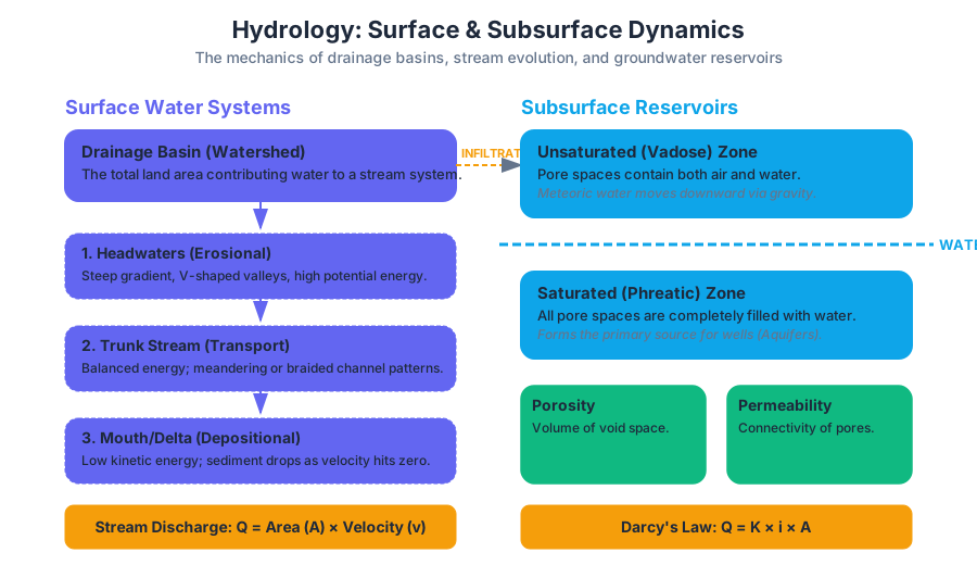
A drainage basin (or watershed) is the fundamental unit of hydrology. It is the total land area that contributes water to a specific stream or river system. These basins are hierarchical; a small creek has its own basin, which is nested within the larger basin of a major river like the Mississippi or the Amazon.
The Anatomy of a Basin
Basins are separated by topographical highs known as drainage divides. Water falling on one side of the divide flows into one catchment, while water on the other side enters a different system. Within these basins, streams organize into networks that reflect the underlying geology and climate.
The Law of Stream Numbers: In a mature drainage system, there is a highly regular inverse relationship between the stream order and the number of stream segments of that order. This fractal-like organization ensures efficient transport of water and sediment.
Stream Dynamics and Sediment Transport
Streams perform three primary geological tasks: erosion, transportation, and deposition. The energy available for these tasks is determined by the stream gradient (slope) and the discharge ($Q$), defined as the volume of water passing a point per unit of time.
| Feature | Description | Primary Energy State |
|---|---|---|
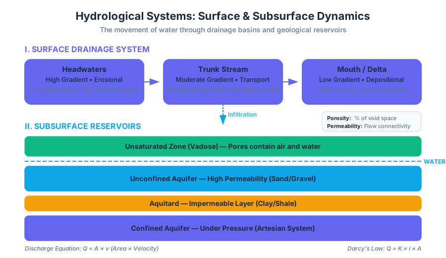
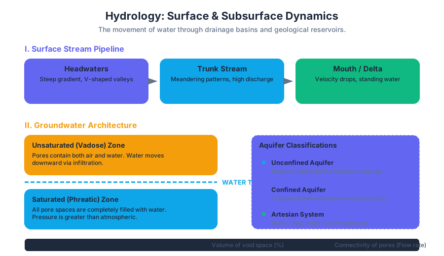
| Headwaters | Steep gradient, V-shaped valleys, high velocity relative to bed roughness. | High Potential Energy; Erosional dominance. |
| Trunk Stream | Moderate gradient, meandering or braided patterns, high discharge. | Balanced; Transport dominance. |
| Mouth/Delta | Near-zero gradient, velocity drops as it enters a standing body of water. | Low Kinetic Energy; Depositional dominance. |
Groundwater: The Hidden Reservoir
Groundwater represents approximately 98% of all liquid freshwater on Earth. It is not found in "underground lakes" (except in rare cavernous limestone), but rather within the microscopic pores of soil and the fractures of bedrock.
Porosity and Permeability
The ability of a geological material to hold and transmit water is defined by two distinct but related properties:
- Porosity: The percentage of the total volume of a rock or sediment that consists of open spaces (voids).
- Permeability: The capacity of a material to transmit a fluid. This depends on the size of the pores and how well they are interconnected.
| Material | Porosity (%) | Permeability | Hydrologic Role |
|---|---|---|---|
| Unconsolidated Gravel | 25–40% | Very High | Excellent Aquifer |
| Sandstone | 5–30% | Moderate to High | Common Aquifer |
| Clay | 40–70% | Very Low | Aquitard (blocks flow) |
| Unfractured Granite | <1% | Negligible | Aquiclude (impermeable) |
| Fractured Shale | 0–10% | Low to Moderate | Variable |
The Water Table and Zones of Saturation
As meteoric water (rain/snow) infiltrates the ground, it moves through the unsaturated zone (or vadose zone), where pores contain both air and water. Eventually, it reaches the saturated zone (or phreatic zone), where all pores are filled with water. The upper boundary of this saturated zone is the Water Table.
The water table is not flat; it typically mimics the surface topography, though in a more subdued fashion. It rises under hills and sinks toward valleys, where it often intersects the surface to form springs, lakes, or streams.
Aquifers and Darcy’s Law
An aquifer is a permeable geological unit that can yield significant quantities of water. Conversely, an aquitard is a low-permeability layer that restricts flow.
Types of Aquifers
- Unconfined Aquifer: The water table is its upper boundary. It is directly connected to the surface and is easily recharged but also easily contaminated.
- Confined Aquifer: Sandwiched between two aquitards. The water is often under pressure, creating a potentiometric surface. If a well is drilled into a confined aquifer and the water rises above the top of the aquifer, it is called an artesian well.
The Physics of Flow: Darcy's Law
Groundwater does not move like a river; it moves at rates typically measured in centimeters per day. This flow is governed by the hydraulic gradient (the slope of the water table).
Q = -K \cdot A \cdot \frac{dh}{dl}
Where:
Q: Discharge (volume/time)K: Hydraulic Conductivity (a measure of permeability)A: Cross-sectional areadh/dl: Hydraulic gradient (change in head over distance)
Mathematical Derivation: Steady-State Flow
To model how groundwater behaves around a pumping well, we use the Laplace equation in radial coordinates to determine the "Cone of Depression."
DERIVATION: Radial Flow to a Well (Theis/Thiem Equation)

Given the Darcy flux in radial coordinates:
q_r = -K * (dh/dr)

The total flow Q through a cylinder of surface area 2*pi*r*b (where b is aquifer thickness):
Q = (2 * pi * r * b) * K * (dh/dr)

Rearranging for dh:
dh = (Q / (2 * pi * b * K)) * (dr / r)

Integrating from r1 to r2:
h2 - h1 = (Q / (2 * pi * T)) * ln(r2 / r1)

Where T = K*b (Transmissivity).
This shows that the drawdown (h2-h1) increases logarithmically as you approach the well.
Flood Hazards: Risk and Recurrence
Flooding is the most frequent and costly natural disaster globally. Geologically, a flood occurs when a stream's discharge exceeds the capacity of its channel, causing water to overflow onto the floodplain.
Types of Floods
- Regional Floods: Result from prolonged, widespread precipitation (e.g., seasonal snowmelt or monsoon rains). They develop slowly and last for weeks.
- Flash Floods: High-intensity, short-duration events, often in arid regions or urban environments with high proportions of impervious surfaces.
- Ice-Jam Floods: Occur in cold climates when broken ice blocks the flow of a river, causing upstream flooding.
Flood Frequency Analysis
The "100-year flood" is a widely misunderstood term. It does not mean a flood happens exactly every 100 years. Rather, it means there is a 1% probability of such a flood occurring in any given year.
| Recurrence Interval ($T$) | Annual Probability ($P$) | Significance |
|---|---|---|
| 2-year | 50% | Bankfull discharge; shapes the channel. |
| 10-year | 10% | Minor nuisance flooding; covers low floodplains. |
| 50-year | 2% | Significant damage to infrastructure. |
| 100-year | 1% | Standard for insurance and zoning regulations. |
| 500-year | 0.2% | Extreme event; catastrophic failure of levees. |
Human Impacts and Environmental Challenges
Our interaction with the hydrologic system often leads to unintended consequences.
Groundwater Mining and Subsidence
When groundwater is pumped out faster than it can be recharged (a process called overdraft), the water table drops. This can lead to:
- Cone of Depression: A localized dip in the water table that can leave neighboring shallow wells dry.
- Subsidence: As water is removed from the pores, the sediment grains collapse under the weight of the overlying rock, causing the ground surface to sink. Parts of California's San Joaquin Valley have subsided by over 9 meters due to agricultural pumping.
- Saltwater Intrusion: In coastal areas, over-pumping can pull dense seawater into freshwater aquifers, ruining the water supply.
Urbanization and the Hydrograph
Urbanization fundamentally alters the hydrograph (a plot of discharge vs. time). By replacing soil with pavement (impervious surfaces), we reduce infiltration and increase runoff.
- Lag Time: The time between peak rainfall and peak discharge is shortened.
- Peak Discharge: The maximum flow is significantly higher in urban areas compared to forested catchments, leading to more frequent and severe flash floods.
Key Insight: The "Flashiness" of a stream is a direct metric of the watershed's health. A healthy basin acts like a sponge, slowing water down; a degraded basin acts like a gutter, accelerating it.
Contamination and Remediation
Because groundwater moves so slowly, once an aquifer is contaminated (by industrial solvents, nitrates from fertilizer, or leaking underground storage tanks), it remains contaminated for decades or centuries. Plume dynamics involve complex interactions between the chemical properties of the pollutant and the hydraulic conductivity of the medium.
Summary of Hydrologic Principles
- Conservation of Mass: In any drainage basin, $Inflow - Outflow = \Delta Storage$.
- Gravity-Driven Flow: Both surface and groundwater move from areas of high potential energy (high elevation/pressure) to low potential energy.
- Geological Control: The rate of water movement is dictated by the medium—specifically the porosity and permeability of the substrate.
- Dynamic Equilibrium: Streams constantly adjust their shape and gradient to balance the sediment load they carry with the volume of water available.
Source Materials
Study Geology on Lykke
This course page is free to open: signed out, you can read its first two sections, and signing in, on any plan, opens the rest. The free Lykke Chrome extension syncs your own Canvas courses, so ChatGPT, Claude and Muse can answer from your classes and deadlines. It only reads Canvas.
Add the free extensionSign in to open every section